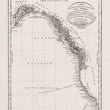


1820 Carta della Parte della Costa Nord-Ouest Dell'America Riconosciuta nelle Estati del 1792, 1793, e 1794...
DESCRIPTION
This map and series of proof plates offers an intricate depiction of the Northwest Coast of North America as charted by Captain George Vancouver during his expeditions from 1792 to 1794. Together, they provide one of the first accurate depictions of the coastal Pacific Northwest from California to Alaska.
The Italian map was published in the French octavo edition circa 1820 and presents Vancouver’s remarkable voyage along the western coastlines, highlighting his detailed observations and rigorous charting of the rugged Pacific Northwest. The map meticulously captures geographical features such as the prominent coastal inlets, islands, and various points of interest along the Pacific shoreline, extending from California through Alaska. Vancouver's route with applicable dates is delineated along the coast.
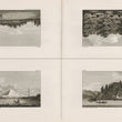
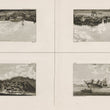
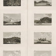
Engraved Plates from Vancouver's Voyage
Accompanying the map are a series of eight engraved proof plates that provide a vivid portrayal of the landscapes and encounters from Vancouver's journey. These engravings showcase scenes along the Northwest coast, including views of indigenous settlements, natural scenery, and encounters between European ships and native communities. Each image reflects the cultural exchanges and the visual richness of North American Pacific Coastal landscapes as they were witnessed during Vancouver’s exploration.
Note: Of the images provided, one image shows all engravings upright for ease of study. The images appear on the page as they are shown in groups of four.
Historical Context and Significance of Vancouver's Voyage
The Vancouver Expedition, commissioned by the British Admiralty, aimed to assert British claims and to clarify the geography of the Pacific Northwest—a region of growing interest to both British and Spanish powers. As the commander, George Vancouver undertook the immense task of charting the coast in unprecedented detail.
His surveys dispelled earlier cartographic myths of a fabled Northwest Passage through the interior of Canada and clarified the intricate network of islands, channels, and bays along the coast. Vancouver’s work would remain one of the most precise and comprehensive cartographic achievements of the era, laying a foundation for future navigation and exploration. His voyage and subsequent maps were instrumental in asserting British presence in the region and contributed significantly to the era’s geopolitical landscape, as nations competed for control over the lucrative fur trade and access to new territories.
The map and engravings from this French edition published in 1820 not only represent an important historical record but also reflect the enduring impact of Vancouver's meticulous exploration on the understanding and mapping of the Pacific Northwest.
CONDITION
1200 W. 35th Street #425 Chicago, IL 60609 | P: (312) 496 - 3622


