


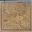


1855 Monk's New American Map Exhibiting the Larger Portion of North America Embracing the United States and Territories
Monk's Standard American Map Exhibiting the larger portion of North America; Embracing The United States And Territories, Mexico, And Central America, Including The West India Islands, The Canadas, New Brunswick And Nova Scotia
By: Jacob Monk
Date: 1855 (dated) Philadelphia
Dimensions: 61 x 64 inches (155 x 163 cm)
A most impressive mid-19th century wall map of the United States, Mexico, Central America and part of the Caribbean. The map was first published by Jacob Monk out of Baltimore in 1854. This is the fourth state of his map, dated 1855.
The map shows America at a most interesting time in its history, after the Mexican-American War, during the height of the California Gold Rush, and prior to the onset of the Civil War. Westward expansion was well underway but not yet with the assistance of transcontinental railways. Settlers, prospectors, and fur trappers would either have to purchase an expensive ticket for passage by sea to California or make a multi-thousand mile trek overland on foot and part of long wagon trains.
The line of civilization is evident upon first glance of the map, where towns and settlements within states halt and large western territories take over. The map shows Texas in its present form having joined the Union 10 years earlier as the 28th state, the New Mexico Territory stretches from Texas to California, the Utah Territory from the Kansas Territory to California, and the Washington and Oregon Territories from the Pacific Ocean to the Nebraska Territory, which is shown in its largest form. The Minnesota Territory includes much of what would become Dakota and Indian Territory (present-day Oklahoma) is occupied by the "Five Civilized Tribes," the Cherokees, Chickasaws, Choctaws, Creeks, and Seminoles, that were forcibly removed from the southern states in the decades prior.
Over the next three decades the country would undergo a major transformation with the end of Slavery, influx of European immigrants, construction of railroads, and the towns that would spring up along it's rails. Throughout this time there would be countless battles and skirmishes between Native American tribes and the United States Military that would ultimately favor the united states with the near extermination of the American Bison and control over vast hunting grounds. This map offers a look at the country prior to all of this change, filled with names of tribes in the ancestral locations, crossed the routes of early explorers and trailblazers, supposed courses of rivers, and proposed railroad lines.
The map is surrounded by an decorative floral border with important government buildings depicted in the corners. In the lower left is a world map on the Mercator Projection and a list of existing counties and large towns in the United States. A number of vignettes illustrating schooners, tall ships, and steam-powered vessels provide a sense of active trade and travel by sea.
Condition: This large wall map is in B+ condition with new wooden rails securely attached to the map that offers deep color on sturdy paper that has darkened with age. Some minor scuffs, cracks, and stains are apparent but not numerous and do not distract from the overall image.
Inventory #12476
1200 W. 35th Street #425 Chicago, IL 60609 | P: (312) 496 - 3622