


1855 / 1861 Transcontinental Railroad Survey from Missouri to the Wasatch Mountains, Utah - 38th & 39th Parallels
DESCRIPTION
This is a remarkably preserved example of the original survey for what would later become the eastern portion of the Central Pacific Railway the first transcontinental railroad of the United States. The survey consists of four maps that surveyed a potential route along the 28th and 29th parallels from western Missouri, across the great plains, through the Rocky Mountains of southern Wyoming to the Wasatch Mountains of Utah.
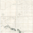
Map No. 1 From the Western Boundary of Missouri to the Mouth of Trap Creek
This first map of this series spans from just west of St. Louis to what is now eastern Kansas and part of Arkansas. Many important early western settlements appear, including Jefferson City, Springfield, Burlington, Independence, Fort Leavenworth, Wyandot City (Kansas City) and Lawrence to name a few. Furthermore, the vast stretches of tributaries extending from the Missouri and Mississippi river are delineated throughout the map. This piece is a great cartographic representation of the area which aptly earned the name the "Gateway to the Western Frontier."
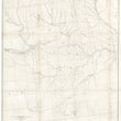
Map No. 2 From the Mouth of Trap Creek to the Santa Fe Crossing
Though this map has the least cartographic detail of all three, its the lack of detail that speaks volumes for how the land once was before mass emigration and industrial farming. Early explorers, military personnel, and emigrants all described (in their own way) this portion of the country to be a vast featureless grassland of rolling hills that would remind many of an open ocean where it is difficult to determine direction. This map spans from Omaha in the northeast to Fort Atchison in the southwest with the Santa Fe Trail and and several proposed railroad routes crossing the map from east to west. The Pawnee in their ancestral lands at top-center. Westward expansion, smallpox, cholera, and frequent clashes with the Sioux would diminish their numbers considerably until they were eventually relocated to a reservation in Oklahoma in the 1870s.
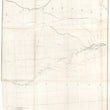
Map No. 3 From the Santa Fe Crossing to Coo-Che-To-Pa Pass
This map features the high plains and Front Range of present-day Colorado, with portions of New Mexico to the south and Wyoming to the north. Some of the most prominent plains tribes are noted throughout the map, including the Apache, Cheyenne, Arapahoe, and Sioux nations. The proposed railroad line can be found in the northern portion of the map while a wealth of interesting topographic detail and historical place names fill the southern portions of the map. Some places of historical and geographic significance include Bent's Fort, Fort Massachusetts, Pike's Peak, and the three mountain parks of Colorado.
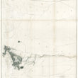
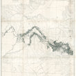
Map No. 4 From Coo-Che-To-Pa Pass to the Wahsatch Mountains
The fourth and final map of this series centers on western Colorado and eastern Utah. The Navajo and Utah tribes are shown to inhabit much of the area The proposed railroad line can be found at the top of the map and the Spanish Trail from Santa Fe to Los Angeles can be found in the lower portion of the map. This map is the first to show Gunnison Canyon and what would become Canyonlands National Park in topographical detail. Gunnison canyon gets its name from this very expedition and the subsequent town would eventually be named after the leader of this expedition, John W. Gunnison.
It was shortly after leaving this area that Gunnison was reportedly attacked by Ute Indians. After the killings, rumors circulated that the indians involved in the massacre were acting under the direction of Brigham Young and an alleged secret militia known as the Danites. Some claim that leaders of the Church of Jesus Christ of Latter-day Saints were initially concerned that the railway would increase the influx of non-Mormon settlers and non-Mormon economic concerns into the territory. We do not support nor deny this notion.
Following the death of Gunnison, his assistant, Lieutenant E. G. Beckwith took command of the surveying party and would complete their journey from the Green River to the Pacific Ocean. The maps that were produced from the 2nd half of this surveying expedition under the command of Beckwith can be found by searching the inventory number 12234.
CONDITION
1200 W. 35th Street #425 Chicago, IL 60609 | P: (312) 496 - 3622