


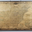


1849 Map of the United States of America including Canada and a large portion of Texas...
Map of the United States of America including Canada and a large portion of Texas... the lands allotted to the Indian Tribes west of the Mississippi.
By: Calvin Smith
Published by: Sherman Smith
Date: 1849 (dated) New York, NY
Dimensions: 64 x 82 inches (162.5 x 208 cm)
A fine example of Calvin Smith's rare and colossal wall map of the United States showing a country in the midst of westward expansion behind the driving ideology of manifest destiny and the recent discovery of gold in California.
Examining the Map
The map presents the United States colored by county, with all townships named. Thousands of cities, towns, ports, forts, and other military outpost are named and all existing railroad lines, canals, and rivers are delineated throughout. In the lower right corner are two inset maps. One map focuses on the southern peninsula of Florida, and includes the original indigenous name Pay-Hai-O-Kee (meaning grass water) as well as the name we are accustomed to today, "the Everglades," for the large, marsh swamp biome that has since become a national park. The second inset shows all of North America, with Texas in its largest form, Upper California and the Oregon Territory, Alaska as Russian Possessions, and the current extent of cartographic knowledge pertaining to the Northwest Passage of which the ill-fated Franklin Expedition had recently been declared lost, never to return.
In the western portion of the map we are presented with a highly detailed visual representation of the ongoing strategy employed by the United States to move all Native America tribes west of the Mississippi. Such tactics would prove devastating for much of America's indigenous population as they were treated similar to one another, assuming people who spent generations as hunter-gatherers would quickly adapt to an agrarian lifestyle. Additionally, the policy would mix tribes from eastern states with local tribes that often thrived in their nomadic lifestyle, following the buffalo herds wherever they roamed. This led to many bloody conflicts as nomadic plains tribes often saw eastern agrarian tribes as invaders on their hunting lands.
Surrounding the map is a ornate border topped with an eagle gripping a shield with the American flag, surrounded by twenty-six stars that specifically represent each state in the Union. Over twenty vignettes are included within this border that represent mid-19th century America. From city views of Louisville, Nashville, New Orleans, Baltimore, New York and more, to depictions of high-society individuals, Native Americans, fur trappers, deer, bison, and beaver, the border encompasses many elements of the evolving country.
History of the Publication
This map was first published in 1843 and was more commonly issued as folding, case map with an optional accompaniment of D. Haskel and C. Smith's A complete Descriptive and Statistical Gazetteer of the United States of America. Less frequently, the map was published as an independent wall map of which this example represents. Revisions and updates were continually made between 1843 and 1852. Joseph H. Colton acquired the steel plates in 1853, changing the border as well as all necessary geographical revisions an continued to issue the map into the 1860s.
Condition: This map is in B condition, originally acquired mounted to a board and covered in over 100 years of filth, the work has been professionally removed from the board, cleaned, and reattached to wood rollers. While some of the original color has faded, the map is very clean and easy to study up close. It will surely make a monumental impact wherever it may reside.
Inventory #12358
1200 W. 35th Street #425 Chicago, IL 60609 | P: (312) 496 - 3622