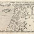

1574 Soria Et Terra Santa Nuova Tavola
By: Girolamo Ruscelli
Date: 1574 (published) Venice
Dimensions: 7.4 x 10.25 inches (18.8 x 26.04 cm)
This is a nice example of a fascinating Ruscelli map from his work La Geografia di Claudio Tolomeo Alessandrino. Ruscelli based much of his work on that of Claudius Ptolemy, and on the atlas maps of Giacomo Gastaldi. This second state issue of the Holy Land and Cyprus is one of the earliest obtainable maps of the region.
The map starts on the Mediterranean coast of Anatolia to the west of Cypress, includes Cypress and names its major cities and extends as far east as the mountains of western Iran and the city of Mosul in modern day Iraq, which here is named Mesopotamia. The Tigris and Euphrates rivers are both delineated and their point of confluence before they empty into the Persian Gulf, the Shatt al Arab, is clearly depicted. The countries of the Levant are all in place and denoted and their topography including mountain ranges and river systems shown in detail. Many biblical cities are named, including those near the Dead Sea such as Sodom and Gomorrah. Large bodies of water are stippled. Italian text on the verso describes the area.
Girolamo Ruscelli (1500-1566) was an Italian cartographer, polymath, humanist and editor, active in Venice during the early 16th century. Ruscelli is best known for his important revision of Ptolemy's Geographia, published posthumously in 1574.
Claudius Ptolemy (85-165 CE), a Roman citizen of Greek descent from Alexandria, was the most influential of Greek astronomers and geographers of his time. He propounded the geocentric theory of the solar system which was to prevail for the next 1400 years.
Giacomo Gastaldi (c.1500-1566) was an Italian astronomer, cartographer and engineer from Villafranca in Piedmont. Many of Ruscelli’s maps are essentially enlarged versions of some of Gastaldi’s maps.
Condition: This map is in A condition. There is minor offsetting near the centerfold.
Inventory #11882
1200 W. 35th Street #425 Chicago, IL 60609 | P: (312) 496 - 3622


