


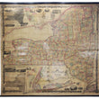


1860 The State of New York from New and Original Surveys...
The State of New York from New and Original Surveys under the direction of J.H. French
By: J. H. French / Robert P. Smith
Date: 1860 (dated) Syracuse, NY
Dimensions: 65.75 x 73.5 inches (167 x 186.7 cm)
A colossal map of the Empire State of New York as it was one year prior to the outbreak of the Civil War. This prodigious work encompass the most accurate geographic information concerning political boundaries and topographic information, with some of the earliest scientific mapping techniques that came out of the mid-19th century, especially pertaining to geology and climatology.
Surrounding the map are numerous inset maps of large and important towns in New York, including Manhattan, Long Island, Syracuse, Oswego, Hudson, Albany, Rochester, Auburn City, Schenectady, Buffalo, Poughkeepsie, and Utica. Other maps which were new for the era include a Geological and Land Patent map and a Meteorological map showing the average mean temperature, depth of rain, and direction of wind throughout the state of New York. Vignettes also fill the map, some of which include a bird's eye view of New York and Brooklyn, Buffalo and Oswego Harbor, Niagara Falls and a depiction of a salt manufacture in Syracuse, to name a few. Atop the map is a time dial for the entire state showing the times of numerous county seats when it is twelve noon at the Dudley observatory in Albany.
According to Walter Ristow in his book "American Maps and Mapmakers: Commercial Cartography in the Nineteenth Century," this map of New York was of "higher quality than the maps of other states published prior to the Civil War." Overall, this is a highly impressive map of New York in terms of its size, artistry, detail, and presentation of scientific data. A staple for any New York map collection and a focal piece in any room.
Condition: Map is in B+ condition with some damp staining along the left hand side and top center portion of the map. Toning of the paper is faint and the original colors are still bold and bright. The map is still firmly attached to its original rollers, but can be removed at the request of the buyer for framing purposes.
Inventory #11577
1200 W. 35th Street #425 Chicago, IL 60609 | P: (312) 496 - 3622