


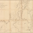


1878 Map of the Shoshone Geyser Basin West End of Shoshone Lake Yellowstone National Park
By: Ferdinand V Hayden
Date: 1878 (dated) Washington D.C.
Dimensions: 24 x 34.75 inches (60 x 88.25 cm)
This is a scarce and early map of the interior of Yellowstone National Park focusing on the Shoshone Geyser Basin.
The map centers on the "Minute Man Geyser Group," that lies just west of a sulphur plateau and the western shore of Shoshone Lake, the second largest lake in Yellowstone National Park. A number of spring lakes feed into Shoshone Creek, mostly from a western slope that is noted in several location with "mud holes," "mud pots," "boiling caldron," and "boiling spring."
It was the geothermal activity above all that astounded some of the earliest white explorers which led to the area becoming a national park. The area shown in this map sits above the southwestern boundary of the great caldera that lies beneath the surface and powers the explosive geysers, and boiling springs throughout the park.
Ferdinand Hayden, known to the Sioux as "man-who-picks-up-stones-running" was one of the most important geologists of the 19th Century. From the 1853 - 1878 he provided the United States government and land speculators with vital information pertaining to the American West as was an instrumental figure in the founding of the world's first national park, Yellowstone. While Hayden first entered the Yellowstone region in 1871, it wasn't until 1878 that he felt his work was complete. It was the later surveys which this map was drawn upon.
Condition: This map is in B condition with prior tape removed and fold separations closed. Minor areas of paper loss have been filled. The map is backed with linen to reinforce the thin and fragile paper it was printed on.
Inventory #11857
1200 W. 35th Street #425 Chicago, IL 60609 | P: (312) 496 - 3622