


1574 Schonladia Nuova
By: Girolamo Ruscelli
Date: 1574 (published) Venice
Dimensions: 7.25 x 10.25 inches (18.4 x 26. cm)
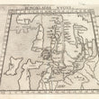
One of the earliest obtainable printed maps of Scandinavia, focusing on what is now, Sweden, Finland, Norway and Denmark.
This Ruscelli trapezoidal map of Scandinavia is from his work La Geografia di Claudio Tolomeo Alessandrino. Though based on the work of Ptolemy it also includes 16th century cartographic information. The map focuses on modern day Finland, but also depicts Sweden, the British Isles including the Hebrides and northern Europe. Also depicted is the island of Thyle, representing Iceland, though its position between Sweden and Finland signifies geographic misinformation. Ruscelli’s map covers territory extending from Moscovia in the east to beyond the Hebrides in the west.
The map includes much topographic information, including cities and towns, ports, mountain ranges, river systems and even some fortifications in the region of the modern day Baltic Republics. Many islands in the Baltic Sea are depicted. The seas and ocean are stippled.
Published in Ruscelli's La Geographi di Claudio Tolomeo, this map of Scandinavia combines Ptolemaic and modern cartographic information. Modern cities listed. Denmark is in a Ptolomeic configuration. Scotland retains its west-east slant, and Thule is larger than Ireland.
Girolamo Ruscelli (1500-1566) was an Italian polymath, humanist, editor, and cartographer active in Venice during the early 16th century. Ruscelli is best known for his important revision of Ptolemy's Geographia, published posthumously in 1574.
Condition: This map is in A condition with a sharp image. Descriptive text in Italian on verso.
Inventory #11790
1200 W. 35th Street #425 Chicago, IL 60609 | P: (312) 496 - 3622