


1574 Nueva Hispana Tabula Nova
By: Girolamo Ruscelli
Date: 1574 (published) Venice
Dimensions: 7.3 x 10.25 inches (18.5 x 26.04 cm)
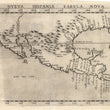
This is the second state of one of the earliest obtainable maps of the area depicted, which covers southern North America, Mexico and Central America. This important Ruscelli map of New Spain from his work La Geografia di Claudio Tolomeo Alessandrino, is based on Gastaldi’s earlier map of the same region, dated 1548. Cartographically the maps are almost identical, with the exception that Yucatan here is properly depicted as a peninsula. Interestingly, it is clear that the initial impulse was to show it as an island, for the reworking of the plate is quite obvious. Place names are the same as in Gastaldi.
Ruscelli’s map depicts the southern half of what would become the United States and Mexico, including Florida and Texas. Many of the rivers which empty into the Gulf of Mexico are depicted, and Cuba and Florida are already named. Mexico City is shown in the middle of its lake and Central America contains significant detail. California is shown as a peninsula. Italian text on the verso describes Mexico and its great Aztec city Tenochtitlan, which flourished between A.D. 1325 and 1521. The Pacific Ocean and the Gulf of Mexico are stippled. Topographical features are in relief, including many mountain chains. Cities, towns, ports and fortifications are delineated.
A better regional representation would not be available until Cornelius van Wyfliet published his map in 1597.
Girolamo Ruscelli (1500s-1566) was an Italian polymath, humanist, editor, and cartographer active in Venice during the early 16th century. Ruscelli is best known for his important revision of Ptolemy's Geographia, published posthumously in 1574.
Condition: This map is in A condition with a strong impression aside from the left edge. Full margins on all sides and clean paper.
Inventory #11716
1200 W. 35th Street #425 Chicago, IL 60609 | P: (312) 496 - 3622