


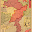


1904 Map of the Russo-Japanese War Battlegrounds
By: Nakai Tokujiro
Date: Nov 3, 1904 (dated) Osaka, Japan | Meiji 37
Dimensions: 20.5 x 30 inches (52 x 76 cm)
This is an antique map of the Russo-Japanese war's battlegrounds throughout Manchuria and Korea dated November, 1904. The map is loaded with information, noting national and provincial borders, long walls and fences, railways, fortresses, mines of gold, silver, tin, and coal, sea route, submarine cables, capital cities, and topographical features such as mountains and rivers.
The Russo-Japanese War (1904-05) between the Russian Empire and the Empire of Japan was fought over their rival imperial ambitions in Manchuria and Korea. Russia sought a warm-water port on the Pacific Ocean for its navy and for maritime trade. Japan offered to recognize Russian dominance in Manchuria in exchange for control of Korea. After negotiations broke down in 1904, the Japanese Navy opened hostilities by attacking the Russian Eastern Fleet at Port Arthur, China
Relevance of Inset Maps
In late 1904 port Arthur was under siege by the Japanese and the Russians were to give it up in January 1905, hence the relevance of the inset map of port Arthur.
The map that shows much of Asia and Europe in the upper right has to do with the fact that Russia was re-deploying ships from the Baltic sea a fact that was likely known to the Japanese due to the October 21st Dogger bank incident in which the Russian fleet traveling to Japan mistakenly fired on British fishing boats.
The Vladivostok inset map is somewhat self-explanatory, being a close major Russian city it was where Russian ships would deploy from and return to, it was clearly a strategic concern.
Advertisement
In the right hand portion of the map is an advertisement for Asada candy, a medecine that can supposedly treat just about anything. The picture of the advertisement is from a scene from a kabuki play called "Sendaihagi (Russian False Yellow (the name of a flower))". It uses the phrase Sukihara ni meshi from that scene which means "A meal to an empty stomach".
The full text reads: "Asada Ame to a cough, a meal to an empty stomach" meaning as much as a meal is the best cure for an empty stomach Asada Ame is the best cure for a cough. It also sounds really good to say in Japanese "tanseki ni asada ame, sukihara ni meshi"
Condition: This map is in A condition originally folded, now flattened and backed with linen for preservation and presentation purposes. Margins are full on all sides and the color is bold.
Inventory #11711
1200 W. 35th Street #425 Chicago, IL 60609 | P: (312) 496 - 3622