


1878 Map of the Lower Geyser Basin Yellowstone National Park
By: Ferdinand V Hayden
Date: 1878 (dated) Washington D.C.
Dimensions: 24 x 34.75 inches (60 x 88.25 cm)
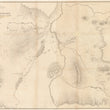
This is a scarce and early map of the interior of Yellowstone National Park focusing on the lower geyser basin, which is one of the most frequently visited areas of the park.
The map centers on "Marshy Ponds," which is now known as "Goose Lake," adjacent to "Firehole River," which runs North and South. This river connects to "Sentinel Creek," which is known today as "Madison River," which feeds into the park just above the popular West Entrance. Geothermic attractions shown within the map include the "White Dome," "Fountain," "Camp," "Butte," "East Fork," "River," and "Fairy Fall" Geyser Groups, In the lower left portion, Twin Buttes and the Crater Lakes are depicted with delicate hachure work that shows elevation change.
Ferdinand Hayden, known to the Sioux as "man-who-picks-up- stones-running" was one of the most important geologists of the 19th Century. From the 1853 - 1878 he provided the United States government and land speculators with vital information pertaining to the American West as was an instrumental figure in the founding of the world's first national park, Yellowstone. While Hayden first entered the Yellowstone region in 1871, it wasn't until 1878 that he felt his work was complete. It was the later surveys which this map was drawn upon.
Condition: This map is in B condition with prior tape removed and fold separations closed. Minor areas of paper loss (most notably in the compass rose) have been filled. The map is backed with linen to reinforce the thin and fragile paper it was printed on.
Inventory #11855
1200 W. 35th Street #425 Chicago, IL 60609 | P: (312) 496 - 3622