

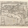

1574 Europae Tabula V
By: Girolamo Ruscelli
Date: 1574 (published) Venice
Dimensions: 7.25 x 10.25 inches (18.42 x 26.04 cm) plate size
This highly desirable Ruscelli map in trapezoid form is from his work La Geografia di Claudio Tolomeo Alessandrino. Based on the work of Ptolemy, it depicts Italy, Sicily, Sardinia and Corsica along with territories in southern Europe adjacent to Italy and the Adriatic Sea. In addition, it extends into Germany, depicts the Balkans and Carpathians, and goes as far as Macedonia in the south. Cities are marked with miniature vignettes whose elaborateness or lack of it serves to convey the size and importance of each city. Both cities and regions are rendered in Latin on the recto.
The map is fascinating in its depiction of the area, with much topographical detail, including mountain ranges and river systems. carefully delineated. Islands in the Adriatic are also denoted and named. The shape of Italy, specifically the curvature of its boot shape, differs significantly from other maps of the day, many of which resemble more closely the true shape of Italy in a modern-day satellite photo than does Ruscelli’s.
Girolamo Ruscelli (1500-1566) was an Italian polymath, humanist, editor, alchemist and cartographer active in Venice during the early 16th century. Ruscelli is best known for his important revision of Ptolemy's Geographia, published posthumously in 1574.
Claudius Ptolemy (85-165 CE), a Roman citizen of Greek descent from Alexandria, was the most influential of Greek astronomers and geographers of his time. He propounded the geocentric theory of the solar system which was to prevail for the next 1400 years.
Condition: This map is in A condition. Heavily inked with some minimal residue, slight discoloration at the centerfold, otherwise sharp impression. Italian text on the verso.
Inventory #11796
1200 W. 35th Street #425 Chicago, IL 60609 | P: (312) 496 - 3622