


1752 Carte de la Louisiane Par le S d’Anville
By: Jean-Baptiste Bourguignon d’Anville
Date: 1752 (Published) Paris
Dimensions: 20.25 x 36 inches (51.44 x 91.44 cm)
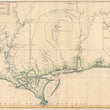
This d’Anville map depicts a large section of the Gulf of Mexico, focusing on the coastline of Louisiana, and is one of the best obtainable large format maps of the region from the mid-eighteenth century.
D’Anville based his work on manuscript maps of Valentin Devin, a member of the 1719 expedition for Compagnie d'Occident (Company of the West, also known as the Mississippi Company). Their objective was to explore and chart the coastline, and over the next several years Devin produced many important maps of the bays and coastal features which occur in the area, including some depicting the coastline between Texas and the Fort Crevecoeur region. These maps served as models for d’Anville.
In the east, the map notes Fort Crevecour (1717-1722) and an unnamed Spanish Fort. The Bays of Pensacola, Mobile and Pacagoula are extensively surveyed and include detailed soundings. Biloxi and Vieux (Old) Biloxi (Fort Maurepas), are depicted, and Fort Louis, established in 1702 and abandoned in 1711, is noted. The map delineates all major river systems including the Mississippi, Arkansas, Red, Osage and Missouri Rivers, with an excellent inset of the Mississippi River Valley from the Arkansas to above the Missouri River. The detail along the Mississippi, both in the main map and the inset of the northern regions, is quite impressive for the period, as is detail in many of the regions and includes other topographical features, such as a number of old Indian roads. The detail along the Pascagoula River is also impressive, including some very early Indian Roads, extending inland to Coue-tchitou ou Village du Grand-Chef, Okitbea, Concah, Concha-tchitou, Tchkachae, etc.
Jean-Baptiste Bourguignon d’Anville (1697-1782) was an important figure in French Cartography in the mid-18th century, publishing a number of large format maps and made to order atlases containing the most up to date cartographic information.Thomas Jefferson acquired some of D'Anville's maps in 1787, and no doubt this was one of them. The map was also utilized for the Lewis & Clark Expedition.
Condition: This map is in excellent condition with original outline color on heavy old paper that has even toning throughout. A few separations are apparent along the top but have been repaired with archival materials.
Inventory #11749
1200 W. 35th St. #425 Chicago, IL 60609 | P: (312) 496 - 3622