


1630 / 1654 Asia recens summa cura delineata
By: Mercator / Hondius / Jan Jansson
Date: 1630 / 1654 (circa) Amsterdam
Dimensions: 14.75 x 19.75 inches (37.5 x 50 cm)
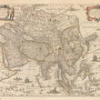
This striking map of Asia is a revision of an earlier map published by the Hondius family. Here the decorative panels have been omitted, resulting in a map which stylistically is moving toward a more scientific and information oriented format with less emphasis on decorative detailing than earlier maps. The map is from the Dutch Golden Age of Cartography and was published in a Mercator-Hondius atlas.
The entire Asian continent is encompassed by the map, including the Arabian Peninsula, the Indian subcontinent, Maritime Southeast Asia, and Japan. A sliver of the American continent, separated from Asia by an unnamed strait, is in the upper right corner. In the lower left, a considerable portion of East Africa is featured.
Place names are noted throughout the map, and are especially numerous in the Arabian Peninsula, Persia, and Southern India, with fewer in parts of Maritime Southeast Asia, Nova Zembla, and Northeast Asia. These areas were still being explored and charted by Europeans, hence the reluctance to include place names. Korea is shown as a peninsula, which is different than on a comparable contemporary map by Blaeu. Japan is shown in a horizontal position, a typical depiction for the early seventeenth century.
Although focused on the geography of the continent, the map is not without embellishment. In Africa, there is a pair of lions in Egypt. An elephant is in upper India, near Lake Chiamay, said to be the source of the Ganges. Both a note and a depiction of the Great Wall of China separate China from Tartary. At sea, several European and Chinese ships are sailing near sea monsters along with a mermaid blowing a horn.
In the upper left is a decorative strapwork title cartouche. Two leather-clad hunters with bows and arrows embellish it. In the opposite top corner, another strapwork cartouche, with floral laurels, carries a dedicatory note to Eylhardo Lubino, or Eilhard Lubin. Lubin (1565-1621) was a German humanist and a Lutheran theologian. He worked as a professor at the University of Rostock, where he published works on the Classics.
French Text on Verso
Condition: Map is in B condition with original color, wide margins, and a clean image on slightly toned paper. There is a long tear extending from the bottom margin just to the left of the centerfold that extends to Persia. It is difficult to spot when looking at the map and is most easily visible when examining the verso. French Text on Verso.
Inventory #11615
1200 W. 35th Street #425 Chicago, IL 60609 | P: (312) 496 - 3622