

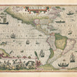
1609 America
By: Jodocus Hondius
Date: 1609 (published) Amsterdam
Dimensions: 12.75 x 19.75 inches (32.4 cm x 50.2 cm)
This superb map of the Americas by Jodocus Hondius is one of the most elaborate and finest examples of Dutch cartography of the early seventeenth century. The map was originally intended for publication in the first edition of Gerard Mercator's atlas, but was a result of Mercator's death in 1594 was not published until 1606, after Hondius had acquired all of the plates from Mercator's descendants.
Despite the great breadth of North America and Virginia’s exaggerated coastline, its geographic features are remarkably accurate for its time. Depicting not only the Americas, but portions of the British Isles and even a small portion of Asia, the map is scientific and decorative at once. It presents a remarkably accurate western coastline of South America and narrows the breadth of Mexico. The coastlines are fully engraved with place names.
The decorative elements of the map spotlight the wonder and intrigue of the New World, its wildlife and indigenous people as it draws from scenes found in the earlier volumes of de Bry's Grand Voyages published at the end of the 16th century. Such illustrations include fanciful sea monsters, a variety of birds and in the lower left quadrant a scene natives preparing an intoxicating drink made from local (possibly cassava) roots.
Frigates on the open seas are flying a variety of colors, and canoes made by native peoples are depicted, including a canoe made of a tree trunk and another in the north Atlantic showing a Greenlander in a kayak wielding a harpoon. In the top left corner, a junk ship represents the proximity of the Orient.
Condition: This map is in A condition with original color, full margins, and no tears or holes. A few small areas along the centerfold show paper pulls and some blotching of the red color but is only noticeable upon close inspection.
Inventory #12714
1200 W. 35th Street #425 Chicago, IL 60609 | P: (312) 496 - 3622