

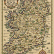
1933 Pratt’s High Test Plan of Ireland
DESCRIPTION
This beautifully illustrated pictorial map of Ireland, presents a romanticized and detailed depiction of Ireland’s geography, history, and cultural heritage. The title, "Pratt’s High Test Plan of Ireland" reflects both its function as a detailed road map and its sponsorship by Pratt’s Petroleum, a British fuel company known for supplying premium-grade gasoline. "High Test" refers to the high-octane fuel promoted by Pratt’s, Petroleum.
The map is rich with historical landmarks, architectural treasures, and scenic landscapes, all intricately drawn and labeled to highlight Ireland’s deep-rooted traditions. Vibrant vignettes dot the countryside, showcasing castles, abbeys, and famous sites such as the Cliffs of Moher, the Rock of Cashel, and the Giant’s Causeway. Alongside these landmarks, charming depictions of rural life, industries, and recreational activities bring the island to life, illustrating everything from horse-drawn carts and traditional farming scenes to the lively culture of Irish towns and villages.
The map’s decorative elements further enhance its aesthetic appeal. At the top, heraldic shields represent Ireland’s four provinces—Connaught, Leinster, Munster, and Ulster—while poetic verses frame the composition, emphasizing a sense of national pride and nostalgia. The borders are adorned with intricate Celtic-inspired patterns, and the compass rose in the lower right corner adds an artistic and functional touch. The roadways, carefully illustrated, reflect the increasing importance of motor travel in the early 20th century, as this map was produced as a promotional piece for Pratt’s, a British petroleum company.
Designed by the artist Alfred Edward Taylor in 1932, this map was created at a time when pictorial cartography was gaining popularity as both a decorative and informative medium. Pratt’s, an oil company known for its association with travel and exploration, used maps like this to appeal to motorists and travelers, encouraging tourism and road travel throughout Ireland. The verso features a wealth of text that describes in detail the many sights and attractions throughout Ireland.
CONDITION
1200 W. 35th Street #425 Chicago, IL 60609 | P: (312) 496 - 3622