

1940 A Cartograph of Monterey Bay Region
DESCRIPTION
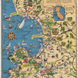
This is a scarce pictorial map of the Monterey Bay region by Ruth Taylor White that truly captures the charm and character of California’s central coast. Featuring a whimsical and exaggerated style, the map highlights major cities such as Santa Cruz, Watsonville, Monterey, and Salinas, illustrating the region’s diverse industries, recreational activities, and agricultural prominence. Small cartoonish figures populate the landscape, engaging in activities like fishing, farming, and tourism, bringing the scene to life with an animated sense of humor and local identity.
The coastline and Monterey Bay are depicted with maritime activity, including sailboats, fishing vessels, and sea life such as whales, seals, and playful swimmers. The inland regions are filled with charming illustrations of farmers harvesting crops, cattle ranching, and logging, reflecting the economic backbone of the area. The map's upper portion features towering redwoods and lumber mills, while the lower sections emphasize agriculture, particularly lettuce and other produce, which have historically been central to the region’s economy. A decorative compass rose and a parchment-style title banner further enhance the vintage aesthetic of the map, making it as much an artistic piece as a geographic representation.
The verso of the map contains promotional text for L. & W. Land Company, a Watsonville-based agricultural business specializing in lettuce and other produce from the fertile Pajaro Valley. The company’s branding, including “Butterfly Brand” and “Daisy Standard Brand,” suggests a strong presence in the fresh produce market. The inclusion of this advertisement implies that the map may have been distributed as a promotional item, possibly through agricultural trade publications, regional tourism offices, or chambers of commerce.
Ruth Taylor White was an American illustrator best known for her whimsical and colorful pictorial maps, which she referred to as carto-graphs. Active primarily from the 1920s through the 1940s, she created a series of vibrant, cartoon-like maps depicting various regions of the United States and beyond, blending cartographic detail with artistic storytelling. Her maps often emphasized local culture, industry, and tourism, using playful caricatures and exaggerated features to bring landscapes to life. White’s work was widely used in travel guides, tourism promotions, and chamber of commerce publications, making geography engaging and accessible to the public. Her distinctive style, filled with humor and charm, captured the essence of mid-century American travel culture and remains highly collectible today.
CONDITION
1200 W. 35th Street #425 Chicago, IL 60609 | P: (312) 496 - 3622