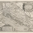

1598 Pannoniae et Illyrici Veteris Tabula
DESCRIPTION
This is a striking, uncolored example of Ortelius's map of Ancient Pannonia and Illyria, that make up parts of present-day Hungary, Croatia, Slovenia, Bosnia, and Serbia. This map was originally published in the 1598 edition of Parergon sive Veteris Geographiae Aliquot Tabulae, a work devoted to mapping the classical world as described by ancient Roman, Greek, and biblical texts.
The map showcases the geography of these ancient regions, emphasizing their importance within the Roman Empire. Richly detailed, it identifies rivers, mountain ranges, settlements, and regions, providing insight into the Roman understanding of this area. Coastal features along the Adriatic Sea (referred to as the Dalmatian Coast) are depicted with remarkable accuracy for the era. The text panel at lower left describes (in Latin) Pannonia as a province with fertile lands, and Illyria as a coastal region rich in trade routes and cultural exchange, bridging the eastern and western parts of the Roman Empire.
Decorative elements include a title cartouche at the top right, framed by classical figures, and a secondary cartouche at the bottom featuring a list of prominent place names. The map is further embellished with a compass rose, ships in the Adriatic Sea, and a coat of arms at the top left. Ortelius's trademark artistic style is evident, blending cartographic precision with elegant design, making the map both a practical and aesthetic achievement.
Pannonia and Illyria in Antiquity
Pannonia and Illyria were provinces of the Roman Empire, located in the western Balkans and central Europe. Pannonia was known for its strategic position along the Danube River, serving as a vital frontier of the Roman Empire. Illyria, encompassing much of the Adriatic coast, was significant for its maritime trade and as a cultural bridge between Rome and Greece. This map emphasizes these regions' historical and geopolitical importance, with detailed annotations and classical references.
Description of the Verso
The verso of this map features extensive Latin text under the title Pannonia et Illyris. This descriptive commentary provides historical, geographical, and cultural context for the regions depicted on the map. The text includes references to classical sources, detailing the Roman provinces' significance, key cities, and landmarks. It discusses the historical development of the area, emphasizing its role within the Roman Empire and its cultural connections to neighboring regions.
In addition, the verso includes illustrations of Roman coins or medallions, further reinforcing the historical narrative and providing a visual link to the ancient world. This combination of cartographic and textual elements exemplifies Ortelius’s commitment to integrating geography with classical scholarship, making his maps invaluable resources for understanding the ancient world.
About of Abraham Ortelius
Abraham Ortelius (1527–1598) was a Flemish cartographer, geographer, and historian, widely regarded as the creator of the first modern atlas, Theatrum Orbis Terrarum (Theatre of the World), published in 1570. Born in Antwerp, Ortelius initially worked as a map engraver and book dealer before gaining recognition for his pioneering work in compiling maps into a unified format. The Theatrum brought together maps from leading cartographers of the time, annotated with Ortelius’s commentary and historical insights.
Ortelius was known for his meticulous attention to detail and his ability to combine cartography with classical scholarship, making his maps not only geographical but also historical and cultural documents. His work had a profound influence on cartography, and his maps are celebrated for their artistic beauty and accuracy. Ortelius was also a close associate of Gerard Mercator, another leading figure in cartography. In 1575, he was appointed the official geographer to King Philip II of Spain, further cementing his legacy as one of the greatest mapmakers in history.
CONDITION
1200 W. 35th Street #425 Chicago, IL 60609 | P: (312) 496 - 3622


