1887 A Chart of the World on Mercator's Projection...
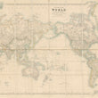
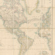
A Chart of the World on Mercator's Projection Showing the principal Ocean Steam Routes, the Submarine Telegraphs & c.
By: J. Arrowsmith
Published by: Edward Stanford
Date: 1887 (dated) London
Dimensions: 26 x 43 inches (66 x 109.25 cm)
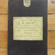
A handsome and clean example of Arrowsmith's map of the World on Mercator's projection, published folding with a slip case by Edward Stanford out of London in 1887.
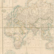
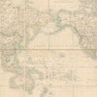
The map centers on the Pacific Ocean with Africa, Europe, and Asia on the left and the Americas on the right. As a result of the Mercator projection which extends lines of latitude to compensate for the curvature of the Earth land near the poles is depicted much larger than that of equatorial regions. For example, while Greenland appears in similar size to Africa, it is much closer in square mileage to Mexico. The benefit of the Mercator projection is that it allowed trans-oceanic vessels to establish a single heading and hit their desired location with ease.
The map presents the world with much of its land explored, save for some portions of Africa's interior and much of Antarctica. With regards to the latter, the publication date of this map places it just before the second wave of Antarctic exploration (known as the Heroic Age) that would include the famed Shackleton Expedition (1907) and that of Amundsen and Scott who would reach the South Pole in 1911 with the latter never making it out alive.
Throughout the oceans we find submarine telegraph lines and shipping routes delineated. While the concept of electrical telegraphy was first pioneered by Samuel Morse and others in the 1830s, the first line wouldn't be laid until 1850 when a line spanned the English Channel, connecting Dover in England to Calais in France. In the following decades, telegraph cables would cross all oceans and played a crucial role in diplomatic, economic, and military communication on an international scale.
This large and exceptional map offers a unique look at the world at a time when new discoveries were becoming harder to achieve but global communication and trade was occurring more frequently and rapidly than ever before.
Condition: Map is in A condition, with no tears or stains and with its original slip case. A red line appears across the Pacific that was done by hand of someone who possibly held this map on a voyage long ago.
Inventory #12715
1200 W. 35th Street #425 Chicago, IL 60609 | P: (312) 496 - 3622


