


1917 Stanford's Map of China and Japan...
Stanford's Map of China and Japan with the adjacent parts of The Russian Empire, Indian, Burma &c.
By: Edward Stanford
Date: 1917 (dated) London
Dimensions: 26.5 x 40 inches (67.3 x 101.5 cm)
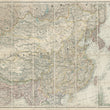
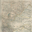
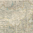
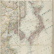
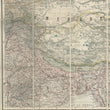
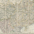
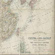
This is a large and intriguing folding map of China and Japan also showing Korea, Taiwan, and parts of Indian, Burma, the Philippines, and Russia, published at the end of WWI.
The map presents a large Chinese Republic in yellow primarily comprised of China, Mongolia, Manchuria, and Tibet. Japan is distinguished in red with Korea and Taiwan under its control. Railways are delineated throughout the map and differentiated by those completed and projected. Extending through much of Sin-Kiang (present day Xinjiang) is a dotted line noted as a "Russian Project." Other important notation defined in the map include submarine telegraph lines, treaty ports and ports open for trade.
The map was published just 5 years after the establishment of the Chinese Republic in 1912, after over 2,000 years of imperial rule ending with the Qing Dynasty. From its beginning, the Chinese Republic faced internal divisions with a lack of central authority, external pressures from WWI and expanding Japanese influence, and a struggle for national unity. Economic challenges, social unrest, and disillusionment with the Treaty of Versailles would lead to the May Fourth Movement in 1919, which marked a shift toward nationalism and a desire for political change.
This period would set the stage for the further development of nationalist movements and the eventual rise of the Chinese Communist Party, leading to the Chinese Civil War and the establishment of the People's Republic of China in 1949.
Condition: Map is in A condition with bright colors on lightly toned paper. It was issued folding, dissected into 32 parts and remains securely bound to its original covers.
Inventory #12710
1200 W. 35th Street #425 Chicago, IL 60609 | P: (312) 496 - 3622