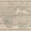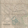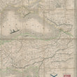


1854 Theatre de la Guerre Carte de la Turquie d'Europe et d'Asia
By: Pierre Tardieu
Date: 1854 (published) Paris
Dimensions: 21 x 30.25 inches (53.5 x 77 cm)
This interesting and informative folding pocket map was drawn up by Pierre Tardieu and printed by Lemercier in Paris in 1854. It depicts the territories involved in the Crimean War, which lasted from October 1853 through February 1856.
The map includes the entire theatre of the war, from Ottoman territories in Europe to the Crimean region and southern Russia. An inset in the upper right depicts the ancient city of Constantinople in some detail, including surviving vestiges of earlier empires. Strategically located, the ancient city has long controlled the lengthy maritime corridor connecting the Black and Mediterranean Seas.
Other territories delineated in the map include southeastern Europe as far west as Greece, Bosnia, Herzegovina, Croatia, Hungary, Transylvania, Bessarabia, Wallachia, and the lower part of the boot of Italy. Anatolia is depicted in its entirety, and the many countries bordering the Black Sea are topographically detailed. The Levant as far south as Baalbek in modern day Lebanon is included.
A large steamship plies the waters of the Black Sea, where a number of maritime routes are designated. In the bottom right corner is the distance legend above which are depicted in color both the Ottoman and Russian battle flags. The map features outline coloring.
The Crimean War
Great Britain, France, and the Ottoman Empire declared war on Russian on March 28, 1854. Despite an ongoing Ottoman presence/threat in eastern Europe, Turkey was supported by several western European powers, including France, Britain, and Sardinia. This support was based on western Europe’s need to prevent Russian expansion in the territories bordering the Black Sea, and the West’s numerous long-established ports. Russian expansion was perceived as a direct threat to European positioning in the Black Sea area, the Mediterranean region and the Middle East.
Numerous of the battles in the war took place in the southern Crimean region, including the engagement at the city of Sevastopol known as the Battle of Balaclava on October 25th of 1854, which inspired the poem The Charge of the Light Brigade, by Alfred, Lord Tennyson, written by Dec 9th, 1854. The Charge, an attempt by an English cavalry unit to destroy Russian battery forces, resulted in catastrophic losses for the unit and the famous line of Lord Tennyson’s poem ‘And into the valley of death rode the six hundred’.
The Crimean War ended with the Treaty of Paris of 30 March 1856. The treaty saw the Russian Empire forced to relinquish control of territories it had won from the Ottomans.
Condition: This linen-backed folding map is in B condition. Normal soiling around the edges, and one section of the map is detached on one side from its neighboring section.
Inventory #12689
1200 W. 35th Street #425 Chicago, IL 60609 | P: (312) 496 - 3622


