


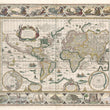


1631 Nova Totius Terrarum Orbis Geographica ac Hydrographica Tabula (4th State)
By: Willem Janszoon Blaeu
Date: 1631 (published) Amsterdam
Dimensions: 17.5 x 22 inches (44.5 x 56 cm)
This magnificent Blaeu map is a true masterpiece of the Golden Age of Dutch Cartography. It is one of the earliest atlas maps to utilize the Mercator projection and one of the more ornate examples of world maps to have been created during that era. Blaeu’s map was first issued in an atlas and was used continuously by him, despite new knowledge of various parts of the world provided by explorers, until 1662.
The map is based on Blaeu’s monumental work dating to 1605 (circa), an oversize double-hemisphere world map of which only one copy is known to be extant. Dutch engraver Josua van de Ende reduced this grand map to standard atlas size for Blaeu, retaining and reflecting basically the same geographic information as the original. The map is both highly detailed and richly embellished, providing geographic and topographical information as well as beauty to the beholder.
The great southern continent is still shown as extending across the entire southern portion of the map, with Tierra del Fuego depicted as part of it. Other geographic misrepresentations include the proportions of various areas of North and South America, including the elongated northwestern coast of North America. The sizes and shapes of land masses in the polar regions are significantly exaggerated. In the upper right corner in the polar region a brief text concerning the Russian region of Novaya Zemlya states: 'Novaya Zemlya (New Land). Discovered in 1596 by Willem Barentszoon from Amsterdam in the name of the States General of the Netherlands.’
Three decorative cartouches embellish the map, all with text in Latin. In the upper left quadrant, the largest of the three contains text stating, ‘America, in the year of our Lord 1492, was first discovered by Christopher Columbus for the king of Castille and was named for Amerigo Vespucci in 1499.’ The remaining cartouches also contain text in Latin, one providing geographic information and the other containing dedicatory and informative text regarding the production of the map. These cartouches are only one element of the decorative aspects of the map.
Allegorical Figures, World Wonders, and Mysterious Embellishments
Along the top border its ornamentation consists of seven figures in oval-shaped vignettes containing allegorical representations of the sun and the moon along with five planets including Mercury, Venus, Mars, Jupiter and Saturn. To balance the top border, Blaeu used similarly shaped vignettes depicting the seven wonders of the ancient world: the Hanging Gardens of Babylon including the tower of Babel in the background, the Colossus of Rhodes, the Pyramids at Giza, the Mausoleum of Halicarnassus before it was destroyed by crusaders, the Temple of Goddess of the Hunt Artemis (Diana) at ancient Ephesus, the statue of Zeus (Jupiter) on Mount Olympus, and the Lighthouse of Alexandria.
The left border consists of four rectangular vignettes representing the four elements, and the right four corresponding in size and shape vignettes representing the four seasons. The vignettes come from works of famous Dutch artists at the end of the 16th century. A number of ships and sea creatures, and five compass roses further embellish the map.
This is a 4th state example with German text on the verso.
Condition: Map is in A condition with bold hand coloring on bright paper with full margins on all sides. Some light foxing is apparent in the lower margin as is two very tiny pin holes and a small slit in the paper along the coast of west Africa. All have been reinforced on the verso using archival materials.
Inventory #12552
1200 W. 35th Street #425 Chicago, IL 60609 | P: (312) 496 - 3622