

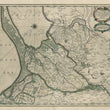

1640 Tractuum Borussiae, circa Gedanum et Elbingam...
Tractuum Borussiae, circa Gedanum et Elbingam, ab incolis Werder appellati, cum adiuncta Neringia, nova et elaboratissima deleninatio
By: Johannes Jansonnius
Date: 1640 (circa) Amsterdam
Dimensions: 16.5 x 19 inches (42 x 48.25 cm)
This masterful map depicting Eastern Prussia, was based on earlier work by Olaf Hansson Svart (Örnehufvud), who had mapped much of the region, including maps detailing mining operations.
The map presented here, created by Jansonnius, is a highly detailed topographical view of the area. Oriented East, the map depicts cities, towns, fortifications and castles, ports, and all rivers and waterways. Danzig (Gdańsk in Polish) is the major city featured. Forested areas are shown in detail. The large, ornate title cartouche has an extension at the lower side which includes a distance legend.
Condition: Map is in A condition with beautiful original color over a strong print impression on clean paper with full margins on all sides.
Inventory #12400
1200 W. 35th Street #425 Chicago, IL 60609 | P: (312) 496 - 3622