


1794 A General Map of North America Drawn from the best Surveys
By: John Russell
Date: 1794 (dated) London
Dimensions: 14.5 x 18.25 inches (37 x 46.5 cm)
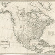
This is a fascinating map of the North American continent impressively detailed with rivers, lakes, settlements, and indigenous tribes. As stated in the title, the map is "drawn from the best surveys," which resulted in some areas, particularly in the north and west portion of the continent to be ripe with detail and others left entirely blank.
The timing of this map is interesting, especially when examining the western coast. While much of the information provided in this map was relatively new, additional information was being obtained by George Vancouver, who was actively charting the Pacific coast from Oregon to Alaska and northeast Asia. Many place names appear that were based on the knowledge of mariners to the region and the cartography of Alaska was derived from third and final voyage of Captain James Cook. In the decades to follow, many additional voyages and overland expeditions of discovery would be made by the British in the Arctic region of North America in search of the Northwest Passage.
In present-day Canada we find a long mountain range running north-south names the Stony Mountains that include a descriptive annotation of "Mountains with Bright Stones." This is an early depiction of the northern Rocky Mountains. The placement of this range is noteworthy as prior maps of the region show a massive bay on the west coast, commonly referred to as the "Sea of the West," with numerous rivers connecting this fabled sea to to Hudson's Bay, providing an intercontinental link to the Pacific Ocean. This lack of any large bay and the addition of this mountain range refutes the possibility for traversing western Canada by water.
Much of what is show in this map includes the earliest states of America, labeled within the map by Roman numerals that are referenced in a key. In central and eastern Canada, a wealth of information is provided, much of it coming from information garnered by the Hudson's Bay Company and their rival the North West Company. The extent of detail in this region shows how one could feasibly navigate (with several portages) from the entrance of the St. Lawrence to the Slave Lake and further north, potentially reaching the Arctic Ocean. Many of the northern reaches of Hudson's Bay are open-ended, suggesting further navigation quite possible.
Condition: This map is in B+ condition, issued folded, now flat with a few very small separations at fold intersections. All margins are complete, except for the bottom margin which is trimmed to the neat-line. The map presents beautifully in its original uncolored state showing signs of light offsetting, which lends itself to its authenticity.
Inventory #12273
1200 W. 35th Street #425 Chicago, IL 60609 | P: (312) 496 - 3622