


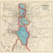


1873 Map of Colorado Territory and Northern Portion of New Mexico Showing the System of Parcs
Map of Colorado Territory and Northern Portion of New Mexico Showing the System of Parcs
By: William Gilpin
Date: 1873 (published) Philadelphia
Dimensions: 20.3 x 21 inches (51.5 x 53.5 cm)
This is a fine example of a scarce folding map of the Colorado Territory and northern New Mexico, produced by the first governor of the Colorado Territory and major proponent of Manifest Destiny, William Gilpin.
The map gives special attention to Gilpin's "system of parcs," which are essentially large valleys or open spaces surrounded by the Rocky Mountains. In this map, Gilpin identifies four main parcs, "North Parc," "Middle Parc," "South Parc," and "San Luis Parc." They were meant to be inviting to future white settles as an inhabitable paradise nestled within what was traditionally perceived to be an enormous obstacle, which is the Rocky Mountains. Several early mining towns are noted within the parcs and the surrounding area as are railroads such as the Union Pacific, Denver Pacific, Rio Grande, and Kansas Pacific, to name a few. The red line running north and south delineates the continental divide and the orange lines depict large mountain ranges that help create a natural boundary for Gilpin's Parcs.
Many interesting landmarks are noted throughout the map. "Round Mound," "Point of Rocks," and "Wagon Mound," which can be found in the lower right portion of the map, helped traders and settlers navigate their way along the Cimarron Route of the Santa Fe Trail. Within Lake County are references to Uncompahgre Mountains, Parc and River, which has its roots in the Uncompahgre band of Ute Native Americans that thrived in the region for centuries. The word Uncompahgre translates to "rocks that make water red." Their most prominent Chief Ouray would later have a mining town named after him and much of their ancestral lands are now part of the Uncompahgre Wilderness area.
Condition: This map is in B+ condition originally issued folded now flat and ready for framing. There are a few minor fold separations that have been reinforced on the verso. Such separations are very common and almost expected with such maps. The colors are bright and bold and the paper is clean save for some light foxing along some of the original folds.
Inventory #11997
1200 W. 35th Street #425 Chicago, IL 60609 | P: (312) 496 - 3622