


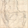


1848 Map of Oregon and Upper California...
Map of Oregon and Upper California from the Surveys of John Charles Freemont and Other Authorities
Drawn By: Charles Preuss Litho By: E. Weber & Co.
Date: 1848 (dated) Baltimore
Dimensions: 33.25 x 26.5 inches (84.5 x 67.3 cm)
Increasingly rare and important map of Upper California and the Oregon Territory drawn from the expeditions of John C. Fremont, Christopher "Kit" Carson, and Charles Preuss to the American Western Frontier. This landmark map has historical importance for a number of reasons, but none more than its support for the prevailing 19th century idea of Manifest Destiny and the cartographic documentation of Freemont's three expeditions.
In 1841, John C. Fremont (28 years old) marries Jesse Benton, daughter of the powerful Missouri Senator Charles Benton whom championed the expansionist movement, a political cause that became known as Manifest Destiny. Through his political power and influence, Benton procured funding and patronage for his new son-in-law John Fremont to lead three separate expeditions into the Oregon Territory, Great Basin, Sierra Nevada Range, and several parts unknown in what was then Upper California. Fremont's first expedition of 1842 ultimately created the official path of the Oregon Trail and lead him to meet the legendary trapper and scout Kit Caron who would guide much of the three expeditions to which Fremont is given credit.
Fremont's 2nd Expedition (1843-44)
Fremont set out with the intention to find an alternate route to Oregon and the Pacific through what is now Colorado. Unable to traverse the Colorado Rockies, the expedition continued along their first route through South Pass, (which was already crowded with emigrants on the Oregon Trail) to the Great Salt Lake where he discovered the previously unknown Mormon settlement, which is noted on the map. The expedition continued northwest to Fort Hall and Fort Boise then along the Snake and Columbia River deep into Oregon country, coming within sight of the Cascade Range and mapping Mount St. Helens and Mount Hood. After a "quick" stop to the British-held Fort Vancouver for supplies, the party turned south to further explore the Sierra Nevada Mountains and the Great Basin of present-day Utah. Fremont was the first American to see Lake Tahoe and accurately determined that the Great Basin was endoheric which means a land that is absent of any rivers that flow to an ocean.
Fremont's 3rd Expedition (1845)
Again, Fremont with the guidance of Kit Carson and cartographic skillset of Charles Preuss set out for the west. This expedition however was partly as a scientific expedition, but also as a military operation under the request of then-president James H. Polk who was willingly trying to bring about a war with Mexico in an effort to conquer new territory and connect the eastern half of the country with California. During this expedition, Fremont split his party into two in an effort to cover more ground and ultimately played a role in taking control of California for Mexico. During this expedition, Fremont named the Golden Gate entrance to San Francisco Bay, and made his way through the old Spanish forts and towns of Monterey, Santa Barbara, Los Angeles, and San Diego.
Court-martial of John C. Fremont
Partially due to Fremont's ignorance with military rank and procedure, he found himself at odds with Col. Richard B. Mason when Brigadier General Stephen W. Kearny appointed Mason the Governor of California, a position which Fremont held after being appointed earlier by Commodore Stockton. Furious with his impending removal as governor, Fremont challenged Mason to a duel, but after the duel was postponed General Kearny had Fremont arrested and sent to Fort Leavenworth where he was court-martialed and charged with disobedience toward a superior officer and military misconduct.
Having been court-marshaled and dismissed from the Army in 1847, Fremont was asked to not publish the details of this last expedition by the Corps of Topographical Engineers as would normally be required. Instead, a geographical memoir comprised his report. It was published nonetheless by Congress at the behest of the powerful Senator Thomas Hart Benton, Fremont's father-in-law. The memoir with which this map appeared is also known as Misc. Doc. No. 148, 30th Congress, 1st Session. Fremont would later make two more expeditions in the west, however these were regarded as far less successful and are deemed of less historical importance than the first three.
Important Cartographic Aspects of Fremont's Map
This map is loaded with detail that only becomes more intriguing as one looks closer. Numerous native American tribes are noted throughout including the Navahoes, Apaches, Pah-Utah, Yumas, Shoshones, Nez-Perce, Umpqua, Chinooks, Wallah-Wallah, and Flatheads to name a few. As mentioned earlier, important early towns, forts, and geographical regions are also named, including "Mormon Settlements" near Great Salt Lake, "El Dorado of Gold Region" near the American River, "Golden Gate," Pyramid Lake, Puebla de Los Angeles, S. Diego, S. Barbara, Monterey, Fort Hall, Fort Boise, South Pass, etc.
As much as this map was an early cartographic breakthrough in the mapping of the west, there is still a lot that was left unknown. One obvious example of this is a vast are in the Great Basin that is simply labeled "Unexplored." Additionally, there is an exaggerated or false mountain range running east-west that is labeled "Dividing Range Between the Waters of the Pacific and the Waters of the Great Basin." The map notes just beneath this range that "These mountains are not explored, being only seen from elevate points on the northern exploring line."
Condition: This spectacular map is in A condition with bold original outline color on clean paper that has been lightly toned with age. The map has been flattened and linen-backed for preservation and presentation purposes.
Inventory #11917
1200 W. 35th Street #425 Chicago, IL 60609 | P: (312) 496 - 3622