

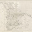
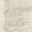
1954 West Coast of Africa Sheet VI VERT to RIVER CACHEO Including the RIVER GAMBIA
DESCRIPTION
A superb working nautical chart of the west coast of Africa (present-day Gambia and Senegal), from Dakar to just south of the River Gambia. This chart was published by the Admiralty under Crown copyright in 1954, updated with small corrections to 1957.
The chart is a detailed hydrographic map, created primarily for navigation, and features an intricate network of coastal lines, soundings, and navigational aids such as compasses and depth markers. The surrounding Atlantic Ocean is represented with various depth readings, aiding mariners in charting safe courses. The chart also includes geographic features like islands, river estuaries, and some inland territories near the coast. Key settlements along the river and coastlines are also indicated, with a detailed focus on the Gambia River, a major waterway in the region.
A Brief History of the Gambia Region
The Gambia River has played a significant role in the history of West Africa, especially during the periods of European exploration and colonization. The river was historically a major artery for trade, attracting Portuguese, French, and British explorers in the 15th and 16th centuries. The region became a key battleground for colonial powers, particularly during the transatlantic slave trade, as control of river access meant dominance in the trade of enslaved people, ivory, and gold. The Gambia was later established as a British colony, with its capital, Bathurst (modern-day Banjul), serving as a critical outpost.
Economic Importance of the Gambia River in the 1950s
In the 1950s, when this nautical chart was produces, the Gambia River had remained an essential economic route for the region. The river was vital for transporting goods such as peanuts (groundnuts), which became the country’s primary export product during this period. The British had established extensive agricultural plantations along the riverbanks, and the Gambia River served as a lifeline for exporting agricultural goods to global markets. Additionally, fishing and riverine trade contributed significantly to the local economy, as the river connected the interior of the country to the coast, making it an indispensable trade route for both local and international markets.
CONDITION
1200 W. 35th Street #425 Chicago, IL 60609 | P: (312) 496 - 3622