


1934 / 1951 River Thames - London to Thames Haven
DESCRIPTION
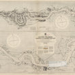
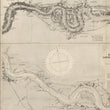
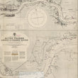
A spectacular mid-century working nautical chart of the River Thames from Vauxhall in London to Thames Haven published by the Admiralty in 1934, updated to 1951. Additional hand annotations update the map further to 1964.
This chart of the River Thames is divided into two maps and include a wealth of information necessary for navigating the river between its mouth and London. Depth soundings, shallow areas, light references, and bridges are noted along the way. Additional detail is given to docks and buildings along the river and with towns and other place names noted throughout. A few sections of the chart have a paper overlay for updated information similar to that of old fire insurance atlases.
CONDITION
1200 W. 35th Street #425 Chicago, IL 60609 | P: (312) 496 - 3622