


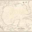


1848 A Chart of the Gulf of Mexico, with plans of the Principal Harbours, & c.
By: J.S. Hobbs
Date: Jan. 1st 1848 (dated) London
Dimensions: 32.5 x 30.5 inches (82.5 x 77.5 cm)
Only known example of this superb Blueback nautical chart of the Gulf of Mexico originally published just one day before the signing of the Treaty of Guadalupe Hidalgo on February 2, 1848 that ended the Mexican-American War. The map shows many early and important settlements and forts within Texas, Louisiana, and Florida.
The map centers on a cluster of depth soundings and wind barbs off the Yucatan Peninsula and includes the entire Gulf Coast of Mexico, Texas, Louisiana, Mississippi, Alabama, and Florida. The western portion of Cuba and the Cayman Islands are also represented in the map. Four compass roses that provide "True" and "Magnetic" North fill the seas with their rhumb lines. Within the Gulf of Mexico, a notation in scripted print that reads as follows, "Throughout the Gulf of Mexico & Seas Adjacent, Northerly Winds are most prevalent from October to March."
Eight additional inset maps provide important navigational information for the Entrances to the Mississippi River, Bar and Entrances of Mobile Bay, Pensacola Harbour, Port of Vera Cruz, Galveston Island and vicinity, San Luis Island on off the South end of Galveston, Tampico Harbour, and the mouth of the Sabine River. The top right corner of the map features vignette views of Lighthouses in Abaco and Gun Cay (Bahamas). Additional lighthouses are identified throughout the carts with red ink and yellow water coloring.
Historically Significant Places in Texas Noted in the Map
In Texas, the map notes important places such as Corpus Christi Rancho positioned on the south end of the entrance to the Nueces River. It was founded as a little trading post by Colonel Henry Lawrence Kinney in 1839 and was known to locals as Kinney's Trading Post. In 1846, General Zachary Taylor set up camp there in preparation for war with Mexico, where they remained until March, when they made their way south to the Rio Grande to enforce it as the new southern border of the Texas. Corpus Christi eventually became incorporated as a town in 1852.
Also included in the map is the town of Victoria, originally founded as Guadalupe Victoria in 1824 by Martín De León whom named the town after the first President of the Republic of Mexico. After Santa Anna was defeated at the Battle of San Jacinto, the town's Mexican residents were driven out by Anglo settlers, who renamed it Victoria. In 1840 the town suffered a devastating Comanche attack lead by Buffalo Hump the legendary war chief and father of Quanah Parker (the last Comanche War Chief). A cholera outbreak further devastated the town in 1846.
Last but not least, the map pays special attention to Galveston Island, city, and bay. During the 1840s, Galveston (aka. The Oleander City) was the main port of entry for the Republic of Texas, taking in a flood of German Immigrants escaping economic hardship, political unrest, riots, rebellion and eventually a revolution in 1848. With the addition of Jewish immigrants and Mexican residents the city became a hub for Union support against slavery during the civil war within what was an otherwise pro-slave, Confederate State. The city experienced tremendous growth for the rest of the 19th century until the devastating hurricane of 1900 destroyed nearly every structure and killed thousands and ground all progress to a halt.
Other Interesting Notations and Important Places
Special attention is paid to the port and city of Vera Cruz, Mexico as a best track to guard against the Northers (winds) is delineated within the main map and detailed inset is included in the lower left corner. The city was the site of many significant battles over a period of hundreds of years. One such battle that occurred within years of this maps' creation was Siege of Vera Cruz in March of 1847 by General Winfield Scott, which is regarded as an important victory for the United States during the Mexican-American War.
In Louisiana, a notation of Terre Bonne can be found, which means "good land," and the fact that it is written in French points to the large French-Cajun population that still resides in the area today. Plaquemines can be found just east, which is a Native American word translated by the French to mean "permission." Today the region extending from New Orleans to the mouth of the Mississippi is part of Plaquemines Parish.
Florida is divided into East Florida and West Florida and had been since the First Treaty of Paris in 1763 at the end of the French and Indian War, that gave all of Florida to the British. For decades West Florida was predominantly French and extended to Louisiana. East Florida was under Spanish control and in the 18th century served as a hideout for pirates and Seminoles that raided colonies in Georgia. During the first half of the 19th century, Florida was under control of the United States, but still divided into East and West with two separate governments.
Within Florida, the map provided indigenous place names with their English translation. For instance, Lake OKee Cho Bee is also noted as Big Water and Pay Hai O Kee (site of the Everglades) is noted as Grass Water. Other places of historical interest found in Florida include the oldest continuously occupied settlement in the United States, St. Augustine, and several early military forts such as Gatlin, Butler, Jupiter, Lauderdale, Delaney and Harrison, to name just a few.
John Stratton Hobbs (1813-1874) was a talented hydrographer and map maker that spent the majority of his professional career making nautical charts for the Norie & Wilson Company. He was elected to the Royal Geographical Society in 1848, the same year this map was originally produced.
Condition: This map is in B condition with narrow margins that exhibit some chipping and a few minor tears. The map was dry mounted to a baking board when we obtained it and has since been removed, displaying the original blue-back paper that has earned the nickname for the maps as "blue backs."
Inventory #12034
1200 W. 35th Street #425 Chicago, IL 60609 | P: (312) 496 - 3622