


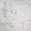


1857 Map of the Territory of the United States from the Mississippi to the Pacific Ocean
Map of the Territory of the United States from the Mississippi to the Pacific Ocean; ordered by Jeff'n Davis, Secretary of War to accompany the reports of the explorations for a railroad route.
By: Lieut. G. K. Warren
Date: 1857 (dated) Washington D.C.
Dimensions: 42.5 x 46.5 inches (108 x 118 cm)
A well-preserved example of one of the most important and complete maps of the western United States to come out of the mid-19th century. This remarkable cartographic work by Lieutenant Gouverneur Kemble Warren is drawn upon nearly half a century of American exploration, military operations, scientific expeditions, and a massive undertaking in government funded land surveying with the intention of identifying the best route of a trans-continental railroad.
Early Visions of a Transcontinental Railroad
The idea for a trans-continental railroad can be traced to a New York business man and importer of goods from China, Asa Whitney. He desperately wanted an overland route to connect his imports of Chinese tea, spices, and other goods from the harbors San Francisco to New York and everywhere in between. In 1846 Whitney proposed to congress for a grant of public land to be used to build the nation's first ever transcontinental railroad from Lake Michigan to the Pacific. Congress voted down his proposal and in 1849 he published a booklet to promote his vision entitled Project for a Railroad to the Pacific, which made the idea of a transcontinental railroad one of the great public issues of the day.
It wasn't long after that in 1853, Secretary of War Jefferson Davis was directed by congress under the provisions of the Army Appropriation Act, to survey possible routes to the Pacific. Four east to west routes, roughly following specific parallels, as well as a north-south route through the coastal states of Washington, Oregon, and California were to be surveyed by parties under the supervision of the Topographical Corps.
Important Events that Created A Window of Opportunity
So what changed since 1846 when Asa Whitney's initial proposal as turned down? For starters, the Mexican-American War came to an end with the signing of the Treaty of Guadaloupe Hidalgo which resulted in the addition of 525,000 square miles of land to the United States. Earlier that same year, gold was discovered at Sutter's Mill in the Sierra Nevada mountains of California, sparking a massive movement of fortune seekers that is well-known today as the 49ers.
In the east however, tensions were rising over the national debate on abolishing slavery. The compromise of 1850 eased tension between the northern and southern states. It consisted of five laws that dealt with the issue of slavery and territorial expansion. Thus, an ideal window of opportunity was provided to unite the country figuratively and physically with a railroad that would connect the existing populations and opportunities of the western states with the resources and willing emigrants of the eastern states.
The Effort, Information, Risk, and Sacrifice Behind this Map
This monumental work, acts as a grad view of the many ongoing surveying expeditions of the American West as well as documentation of information garnered from the many exploring expeditions and military reconnaissance missions and operations from years past. In fact, many of the surveying parties followed much of the routes of Lewis & Clark (1804-06), Long (1819-23) Fremont (1843-44), Sansbury (1849-50) Lient. Albert & Peck (1845) and Colonel Kearny (1846). Many of these routes and others are delineated within the map and in the lower right corner is a list of over forty expeditions, and source maps that preceded this work, beginning with Lewis and Clark in 1804 5-6.
Any expansionist efforts by the United States cannot be undertaken without considering the element of the Native Americans living within the lands surveyed in this map. While many tribes had already been relocated west of the Mississippi onto established reservations, many others where either constantly roaming as their nomadic bands or had established territories, which they would defend to the death. Some were quite peaceable and would offer guidance and trade with the white men of the east, others would torture and kill many the crossed their sights.
The very nature of the job of a land surveyor was extremely dangerous, not just because they were often extremely far from any civilization that could provide supplies and medical attention, but also because many tribes had already come to understand that surveyors were a precursor to land claims by whites and the subsequent development and hostile engagement with the United States Military. Thus, this map offers a great wealth of the most recent cartographic information concerning the location of every Native American tribe known west of the Mississippi.
The Potential Routes for a Trans-continental Railroad.
As previously stated, the map is a grand view of four east to west routes, roughly following specific parallels, as well as a north-south route through the coastal states of Washington, Oregon, and California that were being surveyed.
The following information on these routes was garnered from the Library of Congress.
The ill-fated party under Capt. John W. Gunnison was to explore the route along the 38th and 39th parallels, or the Cochetopoa Pass route, which was advocated by Missouri Senator Thomas Hart Benton. After Gunnison's death at the hands of hostile Indians, Lt. Edward G. Beckwith continued the survey along the 41st parallel.
Capt. Amiel W. Whipple, assistant astronomer of the Mexican Boundary Survey, and Lt. Joseph Christmas Ives surveyed the route along the 35th parallel westward to southern California. This line was favored by Jefferson Davis and was essentially the route traversed by Josiah Gregg in 1839 and later surveyed by Col. John J. Abert.
The most southerly survey, which followed the 32d parallel, was surveyed by Lt. John G. Parke from California along the Gila River to the Pima villages and the Rio Grande. Capt. John Pope mapped the eastern portion of the route from Dona Ana, New Mexico, to the Red River.
A fifth survey, following a north-south orientation, was conducted under the direction of Lt. Robert S. Williamson. This party reconducted topographical survey to locate passes through the Sierra Nevadas and the Coast Range in California in order to determine a route that would connect California, Oregon, and Washington were made under the direction of Lt. Robert S. Williamson.
Additional cartographic details found throughout the map include the locations and names of mountain passes, heights and names of prominent peaks, locations of fresh and salt water lakes, river, larger towns, small settlements, military forts and outposts, and of course, large swaths of "unexplored" land.
Condition: This map is in B condition with some areas of loss along fold intersections and light paper toning along fold lines. Contrary to most example of this map that have been offered in the past, this example has been entirely linen-backed so that it can be easily unrolled or presented in a frame as one piece. While not all lines between the sheets connect evenly the joining of this large map so that is can be studied with ease, is something special.
Inventory #12233
1200 W. 35th Street #425 Chicago, IL 60609 | P: (312) 496 - 3622