


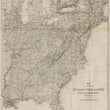
1863 Map to Accompany "My Diary North and South" with the Author's Route Colored
DESCRIPTION
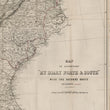
This unique and historic map, titled Map to Accompany "My Diary North and South," was created to illustrate the travels of William Howard Russell, a prominent British war correspondent. Published in conjunction with Russell’s book My Diary North and South (1863), the map charts his journey across the United States during the early years of the American Civil War. It offers a detailed and comprehensive view of the eastern United States, with the author’s route carefully marked in red to provide a visual reference to his travels.
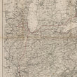
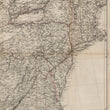
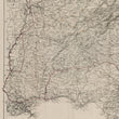
The map extends from the northeastern United States, covering states like New York, Pennsylvania, and Virginia, to the deep South, including Alabama, Mississippi, and Louisiana. Major cities, railroads, and waterways are prominently featured, emphasizing the infrastructure that was crucial to Russell's travels. The topography of the region is also delineated, showing the Appalachian Mountains and key rivers such as the Mississippi and Ohio.
Russell’s journey took him through both Union and Confederate territories, providing a firsthand account of the political, social, and military conditions during this pivotal time in American history. The map is a fascinating companion to his narrative book (not present), allowing readers to trace his path as he documented the contrasts between the North and the South.
Published in London by Bradbury & Evans, the map serves as both a historical artifact and a geographical guide, offering a snapshot of the United States during one of its most tumultuous periods. Its meticulous detail and integration with Russell's writings make it an invaluable resource for understanding the geographic and cultural divisions of the Civil War era.
CONDITION
1200 W. 35th Street #425 Chicago, IL 60609 | P: (312) 496 - 3622