


1889 Map of Oregon
DESCRIPTION
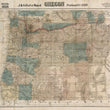
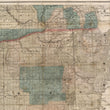
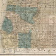
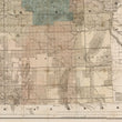
This detailed sectional township and county map of Oregon, published in 1889 by J.K. Gill & Co., provides an intricate view of the state's geography, transportation routes, and land development during the late 19th century. The map reflects Oregon's growth, highlighting the expansion of railroads, settlements, and public lands. The finely engraved details include topographical features, rivers, mountain ranges, and county boundaries, with shaded regions denoting government land grants, military reservations, and forested areas.
One of the defining features of this map is the extensive railroad network, particularly the Oregon Railway & Navigation Co. and the Southern Pacific Railroad, which played a vital role in the state's economic and territorial expansion. A bold red line traces the primary railroad routes, underscoring their importance in linking key settlements and promoting migration and trade. The grid-like survey system, based on the Public Land Survey System (PLSS), divides the state into numbered sections, indicating land ownership and division for settlement and agricultural use.
The map showcases Oregon’s diverse landscape, from the coastal regions of the west to the mountainous and arid regions of the east. Shaded relief highlights the Cascade Range, while rivers such as the Columbia, Willamette, and Snake Rivers are prominently marked, illustrating their significance as natural transportation routes. Large tracts of reserved land, shaded in blue, signify federal holdings, including military reservations, forest lands, and Native American reservations, reflecting the ongoing development and management of land resources in the late 19th century.
J.K. Gill & Co. and Oregon’s Expansion
J.K. Gill & Co., a Portland-based bookseller, map publisher, and stationer, was one of the most notable cartographic firms in the Pacific Northwest during this period. Their maps served as essential tools for settlers, land speculators, and businesses, providing valuable information on transportation, land ownership, and natural resources. This map captures Oregon at a pivotal time of growth and infrastructure development, offering a historical snapshot of the state's transformation from frontier territory to a structured and economically thriving region.
CONDITION
1200 W. 35th Street #425 Chicago, IL 60609 | P: (312) 496 - 3622