

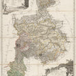
1788 Karte vom Fürstentum Halberstadt, den Grafschaften Wernigerode und Hohnstein und der Abtei Quedlinburg
DESCRIPTION
This decorative 18th century linen-backed folding map is a copper engraving done by Goeck for the Simon Schropp publishing house. It features the Principality of Halberstadt, the counties of Wernigerode and Hohenstein, and Quedlinburg in Germany in what is now Saxony-Anholt, where a Romanesque Abbey still stands. The map depicts the area from Gehrendorf in the north, to Staßfurt and Großberndten in the south, and Wolfenbüttel.
It is embellished by a large title cartouche set in a mountain scene with putti holding coats of arms at the bottom right and hikers enjoying the view nearby. A legend in a scroll style cartouche is in the upper left. The sites featured in the legend include many places of interest, including churches, villages, royal and noble offices, etc., suggesting the map is an 18th century version of a tourist guide. Topography is shown in detail with large areas of forest depicted.
CONDITION
1200 W. 35th Street #425 Chicago, IL 60609 | P: (312) 496 - 3622