


1945 Through France | To Belgium and Back | To The Rhine | Over the Rhine with The 79th Infantry Division - WWII Map
By: Steve Kaliher and Harry D. White
Printed by: Fritz Busche Durckereiges M.B.H.
Date: 1945 (printed) Dortmund, Germany
Dimensions: 26 x 33 inches (66 x 84 cm)
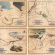
This is a fascinating set of four maps detailing the eleven month advance of the 79th infantry from Utah beach in Normandy, France to Mulheim, Germany. Theses maps were issued separately for soldiers as a memento for their service and are considered very scarce, especially in a complete, original set.
The maps track the movements of the 79th infantry using a black line with arrows indicating their direction of travel. Red lines, note the dates of their progress, which in some places differ by weeks and other places by days, where combat was heavy. Vignettes fill the blank spaces of the map illustrating noteworthy points of the campaign. Also included are several short paragraphs describing with detail in words what pictures cannot. Surrounding each map from the top left corner going clockwise the numerous towns, forts, and rivers reached by the 79th in chronological order.
The Journey of the 79th Infantry Division
The 79th infantry division was activated at Camp Pickett, Virginia on 15 June 1942. They were then sent to Camp Laguna near Yuma, Arizona where they trained in the desert and then to Camp Phillips, Kansas for training in winter conditions. They officially began their tour with a landing on Utah beach on June 14th, eight days after D-Day. After taking the high ground, they were able to take control of the town of Cherbourg France, which was home to several Franch and German fortifications including Fort du Roule.
The 79th infantry endured 248 days of combat, which resulted in 2,475 casualties, 10,701 wounded, and 1,699 missing in action. The covered an enormous amount of territory from the beach of Normandy to the town of Mantes Gassicourt, across the Seine River where they encountered swarms of the Luftwaffe but were protected by the 463rd Anti-Aircraft Artillery Battalion. The dark scene is depicted in the top rght corner of the first map.
Once across, they made great speed to Valenciennes on the border of Belgium, before heading to south to Mirecourt, where they flanked the Germans from the front and back, forcing their surrender. They then spent nearly two months fighting in the Forrest de Parroy before breaking through on October 23rd. Both events are depicted through vignettes in the lower right portion of the second map.
The 79th Infantry eventually crossed the Rhine River into Germany by mid-December and back across in early January of 1945 where they fought a bloody battle in Rittershoffen. Commentary within the third map describes the scene in Rittershoffen, "House by house and stone by stone, lacking blood plasma and ammunition, the 315 inf made Hatten and Rittershoffen a burial ground for many of Hitler's best troops."
The 79th spent the next few weeks making their way to Pont A Mousson where they enjoyed eight days of rest, movies, and clean clothes, while training reinforcements, and making repairs before heading back toward Belgium. The maps skip over the track of the 79th in Belgium, describing the journey in the fourth map "through Luxembourg over bloody ground of the Ardennes Bulge," by train and truck they moved in lace behind the ninth army.
They would cross back into Germany in late February and make their way Northeast from Maastricht, to Dinslaken, Essen and Mulheim, which is depicted on the map as an industrial region that had endured massive destruction. Soon after their arrival, on May 9th, "Victory in Europe Day," ensured their eventual return home and thus the end of their remarkable tour.
This set of maps is a must have for any WWII enthusiast or collector. They show in many ways the level of endurance, hardship, horror, and sense of pride through victory experienced by the 79th infantry and in general, the American soldiers of WWII, known today as the "Greatest Generation."
Condition: Maps were original dry mounted as was a typical practice during the mid-20th Century. They have since been released and linen backed for preservation purposes. Tears, soiling, and some paper toning are apparent on each map, but they are still very pleasing to the eye and in comparable condition to one another.
Inventory #11535
1200 W. 35th Street #425 Chicago, IL 60609 | P: (312) 496 - 3622