


1574 Orbis Descriptio
By: Girolamo Ruscelli
Date: 1574 (published) Venice
Dimensions: 7 x 10.25 (17.8 x 26.04 cm)
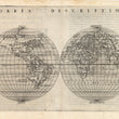
This remarkably accurate for-its-time Ruscelli map is from his atlas Geografia, and is the first known double hemisphere world map to appear in an atlas. Ruscelli based his work on the earlier work of Giacomo Gastaldi’s world map of 1548, his oval world projection, and presented it on Roger Bacon’s circular projection. Ruscelli’s atlas is considered the most comprehensive to have been produced between that of Martin Waldseemüller’s Geographiae in 1513, and Abraham Ortelius’ Theatrum of 1570.
The map is beautifully engraved on copper, making it possible to render far more detail than those produced by woodcut, which before this time had been the standard for printing. Ruscelli’s and Gastaldi’s use of copperplate changed the medium for cartographers and the majority of cartographic works were subsequently produced using this medium.
The continents are remarkably accurately depicted for the time. Gastaldi always sought the most up-to-date geographical information available, making the modern maps in Ruscelli's Geographia among the best modern maps of the period. Aside from Antarctica, all the continents are present, even though North America is presented as an extension of Asia, or vice versa. California is shown as a long peninsula rather than an island, the east coast of North America is quite accurately depicted, as are the Gulf of Mexico, Mexico and Central America. The east coast of South America shows the apocryphal bulge which would remain part of its depiction for some time. The Straits of Magellan are nicely depicted. The eastern hemisphere is quite accurately drawn with Asia including the northwestern portion of North America, marked Terra Incognita and distinctly shown as a land bridge linking Asia and North America, with its coastline labeled Littus incognitum. There is Italian text on the verso.
Girolamo Ruscelli (1500s-1566) was an Italian polymath, humanist, editor, and cartographer active in Venice during the early 16th century. Ruscelli is best known for his important revision of Ptolemy's Geographia, published posthumously in 1574.
Condition: This map is in B+ condition. Even toning with slightly darker toning along the centerfold. Very slight damp staining in image upper right of centerfold.
Inventory #11712
1200 W. 35th Street #425 Chicago, IL 60609 | P: (312) 496 - 3622