


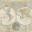


1799 A General Map of the World or Terraqueous Globe
A General Map of the World or Terraqueous Globe, with all the New Discoveries and Marginal Delineations, Containing the Most Interesting Particulars in the Solar, Starry and Mundane Systems
By: Samuel Dunn / Laurie & Whittle
Date: 1799 (dated) London
Dimensions: 42 x 48 inches (106.5 x 122 cm)
A remarkable large format world map featuring the most recently attained cartographic information and most advanced celestial diagrams of the era. Samuel Dunn's monumental map stands out among its contemporaries with a unique balance of beauty and presentation of data that makes is easily recognizable among collectors.
Examining the Cartographic Makeup of the Map
In North America, the United States is shown to extend west to the Mississippi as the Louisiana Purchase would not happen until 1803, expanding United States land claims to the Pacific and prompting the famed expedition of Lewis and Clark. Therefore, much of the interior of this continent is unknown and left to peculation. In the location the Rocky Mountain states of Colorado, Wyoming, and Montana is a note explaining the sources of the Arkansas, Missouri, and Mississippi Rivers to be unknown.
In Canada, much of the information come as a result of the lucrative fur trading industry, then dominated by the Northwest and Hudson Bay Company. This includes the locations of many lakes, river, and native American Tribes. The coastline of the Pacific Northwest is attributed to "Vancouver's Discoveries," and in the far-north, two small delineations of coastline are noted to have been seen by Hearn (1772) and McKenzie, (1786). This vast region that is the Canadian Archipelago would be heavily explored by the British for the next half century, leading to little fame and fortune but a tremendous amount of peril, starvation, death, and in one case, cannibalism (Franklin Expedition of 1845).
Much of the other continents have areas in their interior yet to be explored by Europeans. While earlier maps would fill these empty spaces with speculative lakes, mountains, cities, and vignettes of animals, cannibals, or giants, Dunn chooses to leave these areas blank. This alternative approach had become ever more common among map makers of the 18th century. Simply put, if you don't know what exists in a space on the map, leave it blank. For this reason, we find many of these blank spaces in the interior of South America, Africa, and New Holland (Australia), all of which have more to be desired in the delineation or in the case of Australia, completion of their coastlines.
The last example of leaving out what is unknown can be found with the lack of a southern continent (Antarctica). While mankind had visual confirmation of its existence with the 1820 sighting by Fabian Gottlieb von Bellingshausen and the first landing in 1851 by the American sealer Mercator Cooper, its coastline was largely unknown and therefor omitted from the map. But where the map lacks in an Antarctic coastline, it fills the southern seas with tracks of voyages and notes of sightings of ice fields, isles, and sheets mistaken for land.
Voyages of Captain Cook
As previously stated, the map offers some of the latest cartographic information of the era. This state in particular includes the track and discoveries of the all three voyages of Captain Cook with dates of notable events and sightings. Arguably the most famous voyage was his third expedition (July 12, 1776 – October 4, 1780), that took the Resolution and Discovery to the northern reaches of the Pacific Ocean where them map notes "Impenetrable Ice extending from Continent to Continent, Aug. 18th 1778." Additionally, the map indicates the location and date where Captain Cook was killed in Owhyhee, Feb. 1779. To the east of this location are several islands with a note explaining that that while they appear on Spanish maps and are supposed to be the same islands, they in fact do not exist.
Celestial Charts and Diagrams
This massive wall map of the world dedicates every space outside of the map to a wide array of celestial charts and diagrams, with text explaining in detail the science, discoveries, and theory behind each image. At top-center, a double hemisphere astronomical map shows the constellation of the northern and southern hemisphere. The top left corner is adorned with a map of the solar system showing the orbital paths of all known planets and comets or "blazing stars," noting their date of observation. At bottom center, we find a prominent map of the Moon according to Father Riccioli and to the right is an interesting diagram explaining the changing seasons in relation to our sun, which is presented with a face. Additional planets such as Mars, Venus, Jupiter, and Saturn are scattered throughout the outside spaces of the map.
Condition: This map is in B+ condition with some short tears that have been repaired on the verso and lovely hand coloring. All sheets have been professionally joined and the map is ready for framing with ample margins on all sides.
NOTE: In our image the top right margin appears more narrow than it actually is. This is a result of scanning such a large map.
Inventory #12309
1200 W. 35th Street #425 Chicago, IL 60609 | P: (312) 496 - 3622