


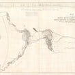


1845 Map of John C. Fremont's 1st and 2nd Expedition to the Rockies, Oregon, and Upper California.
Map of an Exploring Expedition to the Rocky Mountains in the Year 1842 and to Oregon and North California in the Years 1843-44
By: John C. Fremont & George Carl Preuss
Publication: Sen. Ex. Doc. 174, 28th Congress, 2nd Session
Date: 1845 (published) Washington D.C.
Dimensions: 30.5 x 52 inches (77.5 x 132 cm)
A superb large format map and leather-bound report of the monumental 1st and 2nd Fremont Expeditions to the Rocky Mountains, Oregon Territory, and Upper California, which was then part of Mexican Territory.
The map has been professional linen-backed and presents itself with exceptionally. The report which is professionally bound offers a detailed account of the expedition including the meeting of Christopher (Kit) Carson whom would join the expedition and act a lead guide, and purveyor of necessary supplies, water, and food for much of the expedition. Also included in the report are several lithograph views, sketches, and a smaller folding map. For anyone with a desire to know what it was like exploring the unknown Western Frontier of America during the mid-19th Century, this comprehensive report and map are the closest thing to a time-machine that would place you in a saddle next to the legendary Kit Carson, and John Fremont, meeting numerous Native American tribes, early Mormon settlers, Emigrants along the Oregon Trail, Mexican vaqueros, mountain men, and all the natural wonders and dangers the American West can throw your way.
Fremont's First Exploring Expedition to the Rocky Mountains 1842
The trail begins in the pioneer town of Westport, just south of Fort Leavenworth near the confluence of the Kansas, and Missouri River. From there Fremont and his party headed west through what was then referred to as the Great American Desert, thousands of square miles of prairies grass creating a featureless plain often compared to an ocean where at any moment, a chance encounter with a nomadic plains tribe could prove deadly.
Beyond the great plains after a steady increase in elevation the expedition reached the Rocky Mountains which are show in exceptional detail and introduces the three parks, New Park, Old Park, and South Park, which are basins surrounded by towering mountains on all sides. It was in this portion of the journey that the expedition me Christopher (Kit ) Carson and brought him on as a mountain man and guide. Together, they embarked from the Kansas River on June 15, 1842, following the Platte River to the South Pass, and starting from Green River he explored the Wind River Range. It was within this range that Frémont climbed a 13,745-foot mountain (to be named Frémont's Peak) and planted an American flag, thus claiming the Rocky Mountains and the West for the United States, at least in a sense of laying claim that only white men understood.
Returning back to Washington D.C. to report on his first expedition which only lasted about 5 months, Frémont and his wife Jessie wrote a Report of the Exploring Expedition to the Rocky Mountains (the first portion of this book that accompanies the map). The report was published in Newspapers throughout the Eastern states. While it conveyed the massage that the west was certainly wild, unknown, and full of danger, it also brought about the idea of vast open spaces rich with opportunity to those who sought it out.
Fremont's Second Exploring Expedition to Oregon and North California 1843-44
Wasting little time since returning from the first expedition, Fremont left Missouri headed west, this time with nearly twice as many men, a 12-pound howitzer cannon, and plans to meet up with Kit Carson along the Arkansas River in route to the Rockies. Failing to find a new route through the Rockies, the expedition used the Oregon Trail, during which time he passed what has become known as "The Great Migration of 1843" which consisted of an estimated 700 to 1,000 emigrants left for Oregon. Before continuing on to Fort Hall, Fort Boise and along the Snake River to the Columbia River and Oregon, Fremont spent several days exploring Great Salt Lake, making it the first official scientific expedition of the lake. Included within his report and (this book) is the first "accurate" map of Great Salt Lake, published seven years prior to the Stansbury map.
After resupplying at Fort Vancouver, adjacent to present-day Portland Oregon, on the north side of the Columbia River, the expedition continued south along the eastern slope of the Sierra Nevada Mountains where Fremont discovered Pyramid Lake (view included within report). During the mid-winter months Kit Carson led the party from an area in western Nevada that would later be the site of Virginia City, one of the richest mining towns located atop the Comstock Lode, through what is now known as Cason's Pass. While trudging through the snow along Carson's Pass, Fremont became the first American to see Lake Tahoe. They continued along the American River until they reached Sutter's Fort in March, which is now a historic state park located within Sacramento, CA. This report contains a folding map of the route from Lake Tahoe (noted at Mountain Lake) to Nueva Helvetica (Sutter's Fort) along the Rio Sacramento.
After a little over two weeks of some much needed rest and resupplying with an ample stock of provisions and a cavalcade of horses, mules, and cattle, the expedition left Sutter's Fort. They continued south, traversing stream by stream the lush San Joaquin Valley through what would later be home to the cities of Stockton, Fresno, and Bakersfield, and where the map shows a long lake situated at the southern end of the valley. The expedition then caught the "Spanish Trail," a well worn route from Puebla de los Angeles to Santa Fe, New Mexico. They took the trail through present-day Las Vegas (noted of the map as Vegas) heading northeast along the western slope of the Wahsatch Mountains back up to Salt Lake, through South Pass and back east to Missouri along the Oregon Trail.
During this time, Fremont determined the Great Basin to be "endorheic," meaning it has no outflowing rivers that reach any ocean. This important observation contributed greatly to the advancement of North American geography. For years prior, maps had been made that illustrated a longstanding legend of a 'Buenaventura River' which flowed from the Great Basin, through the Sierra Nevada, and into the Pacific. Upon Fremont's return the river was never seen again in maps of the American West.
Within Fremont's map, the Great Basin appears as a large balk area with a long line of text that reads as follows.
THE GREAT BASIN: diameter 11° of latitude 10° of longitude: elevation above the sea between 4 and 5000 feet: surrounded by lofty mountains: contents almost unknown, but believed to be filled with rivers and lakes which have no communication with the sea, deserts and oases which have never been explored, and savage tribes, which no traveler has seen or described.
Publication of Fremont's Expeditions
After reaching St. Louis in August of 1844, ending the greatest exploration of the American West since the Lewis and Clark Expedition of 1803-1806, Fremont and his wife Jessie (whom he had not seen in over a year) made haste to Washington D.C. where the two wrote their second report. While Fremont had done the travels and taken the cartographic notes, astronomical observations, and record of all appropriations required to complete the journey, Jessie was a talented writer who had a knack for compiling all of Fremont's papers into a concise and easy to follow report of her husband's explorations. Senator Buchanan (Jessie's father) ordered the printing of 10,000 copies to be used by settlers and reinforce the idea of westward expansion and manifest destiny.
Condition: The map is in A+ condition with light blue coloring and little staining or damage throughout. The map, issued folded has been flattened and linen-backed for preservation and presentation purposes. The book is also in excellent condition with a firm binding and clean pages with only a corner tear or two to be found.
Inventory #11978
1932 S. Halsted St. #200 Chicago, IL 60608 | P: (312) 496 - 3622