


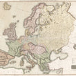


1816 Map of Europe with the Political Divisions after the Peace of Paris and Congress of Vienna
By: John Thomson
Date: 1816 (dated) Edinburgh
Dimensions: 41 x 49 inches (104 x 124.5 cm)
This is a bold and lovely example of John Thomson's four sheet wall map of Europe following the Peace of Paris and the Congress of Vienna. The map is color coded by the recently agreed upon political divisions from the ten-month meeting of European powers chaired by Austrian statesman Klemens von Metternich in Vienna from September, 1814 to June, 1815.
The Congress of Vienna was a series of international diplomatic meetings to discuss and agree upon a possible new layout of the European political and constitutional order after the downfall of the French Emperor Napoleon Bonaparte. The goal was to provide a long-term peace plan by restoring old boundaries and resizing the main powers so they could balance each other while at the same time act as shepherds for the smaller powers.
Negotiating from a position of weakness compared to the other large European powers, France had to give up all its recent conquests, while Prussia, Austria, and Russia made major territorial gains. Prussia added territory from smaller states: Swedish Pomerania, most of the Kingdom of Saxony, and the western part of the former Duchy of Warsaw. Austria gained much of northern Italy. Russia added the central and eastern part of the Duchy of Warsaw. All agreed upon ratifying the new Kingdom of the Netherlands, which had been created just months before from formerly Austrian territory.
Ref: Artz, Frederick B. (1934). Reaction & Revolution: 1814–1832.
Condition: Map is in A condition, with all four sheets professionally joined and ready for immediate framing. Minor fold separations at the margins have been reinforced on the verso using archival materials.
Inventory #12629
1200 W. 35th Street #425 Chicago, IL 60609 | P: (312) 496 - 3622