


1945 Dated Events War Map - 28th Edition
By: Stanley F. Turner / C.C. Peterson
Date: 1945 (published) Coshocton, Ohio
Dimensions: 16.75 x 38.4 inches (42.5 x 97.5 cm)
An unapologetically informative map on the events, dates, and statistics of WWII. This current example is the 28th edition of 30 printed between the years 1942 and 1945, thus making it one of the most complete compilation map of important events and dates of WWII.
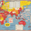
The map centers on southern Asia with most of the western hemisphere absent for the map. Important events with dates are noted throughout in Red (Allies) and Blue (Axis) ink depending on which country is referenced. Atop the map is an inset box titled "Roll Call" which notes the date each nation entered into the war and at the bottom is another inset titled "Box Score of the Pacific War." This inset lists the numbers and types of ships as well as planes lost by both the Japanese and United States.
The right portion features an inset map of Japan noting the location and dates of "The first atomic bombing in history - the beginning of the atomic age." Above this is the iconic image of American troops raising the flag on Iwo Jima and two more images of the bombing of Pearl Harbor and either Hiroshima or Nagasaki. The lower left holds the portraits of the two most celebrated commanders of the United States during WWII, Dwight D. Eisenhower whom oversaw the European campaign and Douglas MacArthur whom oversaw the Pacific campaign. The map is flanked with two lists of dated events, one for the European Area and the other for the Pacific Area.
This mid-century map is ideal for anyone with an interest in the military events of WWII, specifically as it pertains to the role of the United States.
Condition: Map is in B condition with several separations at the fold intersections (a common issues with these maps) that have been reinforced with non-acidic, archival tape on the verso. Map was originally folded, now flat for framing purposes.
Inventory #11918
1200 W. 35th Street #425 Chicago, IL 60609 | P: (312) 496 - 3622