

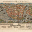

1570 Constantinople des Griechischen Lenserchumbs Hauptstatt/im Land Thracia am moere gelegen
By: Sebastian Munster
Date: 1570 (circa) Basel
Dimensions: 8 x 15 inches (20.3 x 38.1 cm)
This is one of the earliest published maps of the great city of Constantinople as it appeared just seventeen years after its conquest in 1453 by Ottoman Emperor Fetih Mehmed (Mehmet the Conqueror).
The map is accompanied by text in German on both the face and verso. Munster’s map of the great city of Constantinople, while geographically imperfect, conveys a sense of the grandeur of the city which had been the capital of the eastern Roman Empire from the time of Constantine the Great till its fall to the Ottomans in May 1453.
The city had many appelations throughout its history, all of which described its marveled beauty, its great strength of position and its impregnability. Despite the depredations by the Venetians in 1204, the city retained its beauty and allure to the extent that when Medhmed II was yet a boy he had already conceived the idea of seizing what the Ottomans often referred to as ‘The Golden Apple’, and spent his formative years with the idea of capturing the city always foremost in his thoughts.
Sebastian Munster was one of Europe’s foremost mapmakers of the 16th century. Ordained as a priest in 1512, he taught Hebrew at a number of universities, but then began to study maps and in 1525 published his first known map, a map of Germany. He wrote treatises on various topics and continued to publish maps till his death in 1552.
Condition: This hand colored map is in A condition.
Inventory #11216
1200 W. 35th Street #425 Chicago, IL 60609 | P: (312) 496 - 3622