


1574 Il Cuscho Citta Principale della Provincia del Peru
By: Sebastian Munster
Date: 1574 (Published) Basel
Dimensions: 10.5 x 14.75 (26.7 x 37.5 cm)
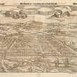
The earliest European depiction of the Peruvian city of Cusco presented as a bird’s eye view.
This grand bird’s eye view of Cusco was well-known in the sixteenth and seventeenth centuries, and was included in a number of publications in which attributions differed according to the publishing house. The map depicts a regular geometric street pattern suggesting that the Incan city had been built according to plan, with a large temple-palace complex dominating the city on the left. The map reveals a well-planned and organized city with both natural and man-made fortifications. Indigenous peoples and well-armored Spaniards are depicted in various areas of the map.
This particular edition, with German text in addition to the Italian Il Cuscho Citta Principale Della Provinci Del Peru emblazoned in the banner, is attributed to Sebastien Munster, even though it was published some twenty four years after his demise. The same map is attributed to at least three 16th century cartographers, including Giovanni Battista Ramusio, whose work Raccolta di Navigationi et Viaggi, was one of the most influential geographical works of the 16th Century, Francois de Belleforest, and Giacoma Gastaldi. The first edition of this map is said to have been published by Ramusio and Gastaldi in 1556, just 22 years following the Spanish conquest of the city, and shows the Incan capital city as it would be been seen by Spanish troops under Pizarro as they made their initial approach. Following its conquest by Spain, the city became the center of the Spanish colonial empire in South America, and would prosper for quite some time.
The verso has a section title page in German and a map of ancient Tenochtitlan (Mexico City) accompanied by text in German.
Condition: Centerfold separation repaired with archival material on the verso. Slight staining at the centerfold and a few small wormholes.
Inventory #11177
1200 W. 35th Street #425 Chicago, IL 60609 | P: (312) 496 - 3622