


1635 Asia noviter delineata
By: Willem Janszoon Blaeu
Date: 1635 (published) Amsterdam
Dimensions: 16 x 22 inches (40.5 x 56 cm)
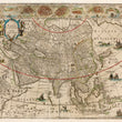
This is a fine example of Willem Blaeu's iconic map of Asia flanked by pairs of carto-figures representing the various peoples of the continent and topped with nine views of important Asian cities and ports of the 17th century.
The map presents many geographical and decorative aspects of this map worth noting. In the north the long-believed existence of the Northeast Passage is revealed as the land mass Nova Zembla is mapped with no east coast and a clear passage is shown to exist to the Anian Straight that opens to the Pacific.
Korea is featured as an island just west of the abnormally shaped Japan. The Great Wall of China can be found separating China from the Mongolians of Tartaria. The Spice Islands are depicted with most of the north and west coasts mapped in detail while many of the south and eastern coasts are blank. This shows the extent of Dutch cartographic knowledge and their areas of occupation during the mid-17th century spice trade.
Several indigenous animals are scattered throughout the map including an elephant just north of a large lake that was believed to be the source of the Ganges, when in actuality it was the Himalayas that had yet to be seen by European eyes. A Bactrian camel and its master can be seen just west of the Great Wall of China and a lion is depicted on the prowl in northern Africa.
The oceans are accented with 5 sailing ships a sea monster in the Pacific and a merman blowing a conch shell in the Indian Ocean.
Dutch text on verso.
Condition: This map is in A condition, cleaned to remove soiling and foxing with full margins on all sides that have a few marginal tear repairs.
Inventory #12093
1200 W. 35th Street #425 Chicago, IL 60609 | P: (312) 496 - 3622