


1574 Roma
By: Georg Braun and Franz Hogenberg
Date: 1574 (Published) Cologne
Dimensions: 13.25 x 19 inches (33.7 x 48.3 cm)
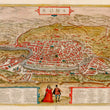
This marvelous map of sixteenth century Rome comes from Georg Braun and Franz Hogenberg’s Civitates Orbis Terrarum, the atlas of cities of the world recognized as one of the greatest achievements of late 16th and early 17th century European cartography. The bird’s-eye view of the city depicts Rome as it appeared circa 1550, with extant ruins of the ancient city easy to find.
Braun took great pains to provide detailed information in print, and provided a numbered guide in Latin to noteworthy sites in the two insets. A few of the features include the Pantheon, the Coliseum, the Arch of Constantine, and the Forum Romanum. In the lower quadrant can be seen the Papal Palace of the Vatican, and the Obelisk from the circus of Caligula and Nero. Latin text on the verso provides additional information about the city.
Georg Braun (1541-1622) was born and died in Cologne. His primary vocation was as Catholic cleric; he spent thirty-seven years as canon and dean at the church St. Maria ad Gradus, in Cologne. Braun was the chief editor of the Civitates Orbis Terrarum, the greatest book of town views of that time to be published. His job entailed hiring artists, acquiring source material for the maps and views, and writing the text. In this role, he was assisted by Abraham Ortelius. Braun lived into his 80s, and he was the only member of the original team to witness the publication of the sixth volume in 1617.
Frans Hogenberg (ca. 1540-ca. 1590) was a Flemish and German engraver and mapmaker who also painted. He was born in Mechelen, south of Antwerp, the son of wood engraver and etcher Nicolas Hogenberg. Together with his father, brother (Remigius), uncle, and cousins, Frans was a member of a prominent artistic family in the Netherlands. During the 1550s, he worked in Antwerp with the famous mapmaker Abraham Ortelius. There, he engraved the maps for Ortelius’ groundbreaking first atlas, published in Antwerp in 1570. Later, Ortelius supported Hogenberg with information for the Civitates orbis terrarium. Hogenberg engraved the majority of the work’s 546 prospects and views.
Condition: This map is in A condition with full margins on all sides. A small break in the paper is apparent in along the top left plate impression where the paper has thinned.
Inventory #12071
1200 W. 35th Street #425 Chicago, IL 60609 | P: (312) 496 - 3622