


1872 Johnson's California also Utah, Nevada, Colorado New Mexico and Arizona
By: Johnson and Ward
Date: 1872 (published) New York
Dimensions: 17 x 24 inches (43 x 61 cm)
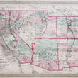
This is an original antique map of the Southwestern United States which includes the states of California, Utah, Nevada, Colorado New Mexico and Arizona, published by Alvin J. Johnson out of New York in 1872. The map is identifiable as the 1872 state by the top page numbers and the adition of Bent and Las Animas counties in Colorado. It is color coded by county and shows lakes, rivers, railroads, towns, military forts, mining claims and the locations of numerous Native American Tribes.
This map is one of several maps of the American West where the boundaries and configuration of territories changed almost yearly. Much of the geography of the western territories is still unknown and it shows in the map as large swaths of land are depicted featureless including the area of the Grand Canyon. The names of many Native American tribes some of which include, the Cheyenne, Navajo, Yampais, Apaches, and Mojaves to name a few. Numerous military forts and frontier outposts offer contrast in the map to the native population as a historical documentation of the struggle over the west.
Routes of explorers and military commanders such a Fremont, Gunnison, and Washington can be traced throughout the map as well as the famous Union Pacific Railroad which had been completed just three years prior to the publication of this map. Other proposed railroads appear mostly in the southern portion of the map.
A notable increase in gold and silver mine claims brought about a massive influx of prospectors and new towns to the region which is evident when comparing this map to its earlier counterparts. Mountain peaks with the height of their summit and notations on land topography complete all encompassing view of the American West, making this map a "must have" for anyone with in interest in its history.
Condition: This map is in B+ condition with bold original color on fine paper with ample margins on all sides, some of which have minor tears that do not come near the image. Some light staining is apparent along the centerfold and at either end of the side margins but does not distract from the overall map image.
Inventory #NA151-3
1200 W. 35th Street #425 Chicago, IL 60609 | P: (312) 496 - 3622