Our Gallery is Open | Please Contact Us To Schedule Your Visit.

Antique Map: Johnson's Maine, 1862
Load image into Gallery viewer, Antique Map: Johnson's Maine, 1862

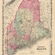
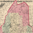
1862 Johnson's Maine

Regular price $ 125.00

Unit price per 

By: Johnson and Ward

Date: 1862 (published) New York

Dimensions: 14 x 17 inches (35.5 x 43.2 cm)

This is an original antique map of Maine published by Johnson and Ward out of New York in 1862. The map is color coded by county with townships also identified and shows railroads, wagon roads, rivers, canals, ports, large towns, and villages of the mid-19th century.

Condition: This map is in A condition with bold original color on fine paper with ample margins on all sides. Some light foxing and paper toning is apparent.

Inventory #NA107-2

1200 W. 35th Street #425 Chicago, IL 60609 | P: (312) 496 - 3622

Close (esc)

Join Our Newsletter

Interested in maps, prints, and upcoming related events? Sign up for our newsletter for fresh NWC inventory and announcements.

Age verification

By clicking enter you are verifying that you are old enough to consume alcohol.

Search

Shopping Cart

Your cart is currently empty.
Shop now