


1861 Johnson's New England
By: Johnson and Browning
Date: 1861 (published) New York
Dimensions: 25 x 18 inches (63.5 x 45.7 cm)
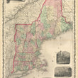
This is an original antique map of New England published by Johnson and Browning out of New York in 1861. The map includes the states of Maine, Vermont, New Hampshire, Massachusetts, Rhode Island, and Connecticut.
The map is color coded by county with townships also identified and shows railroads, wagon roads, rivers, canals, ports, major cities and villages of the mid-19th century. Surrounding the map are five vignettes of a suspension bridge near Niagara Falls, observatories at Cambridge, Yale, and Amherst College, and a view of Marshfield, the homestead of the late Daniel Webster.
Condition: This map is in B+ condition with some light toning and a minor fold separation that has been reinforced on the verso.
Inventory #NA106
1200 W. 35th Street #425 Chicago, IL 60609 | P: (312) 496 - 3622