


1720 Accurater Grundriß und Prospect Der Kön. Schwed. Reichs. u. Hauptstadt Stockholm
By: Johann Baptist Homann
Date: 1720 (published) Nuremberg
Dimensions: 19 x 22.5 inches (48.3 x 57.2 cm)
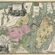
This superb early eighteenth century map of Stockholm in full original hand colour is from Homann’s Maior Atlas Superiore. The map depicts Stockholm as it was at the time of the Great Northern War, when Russia, Denmark-Norway, and Saxony-Poland challenged the supremacy of Sweden in the Baltic area.
Sweden had enjoyed an era of economic and territorial expansion in the Baltic area throughout the 16th and 17th centuries which ultimately antagonized most of its neighbors, who formed various coalitions and alliances in order to gain military advantage. The war ended in 1721, with Sweden ceding significant territories and with Russia emerging as a major power in the region under Peter the Great, when it became known as the Russian Empire rather than the Russian Tsardom as it had been known previously.
Stockholm had significantly benefited during the time of Sweden’s expansion, and though the map was drawn toward the end of the conflict, it reflects the prosperity and growth which preceded it. The districts of the city are coloured in pale shades of pink, yellow and green.
Numerous seagoing vessels are featured along the shoreline, and in the sea two warships at full sail are depicted firing their cannons. Homann details 28 alphanumeric points of interest in the city which correspond to a legend in the lower right corner. The points enumerate parks, palaces, churches, markets and government buildings. The bottom left corner contains a distance legend in a vignette featuring men and women in Swedish national costume of the day. The title cartouche includes a vignette of an allegoric figure in classical costume with a lion entering the scene from behind the cartouche.
Johann Baptist Homann was a German engraver and cartographer, and Imperial Geographer to Charles VI, the Holy Roman Emperor. He enjoyed royal patronage, and in 1702 established a publishing house in Nuremberg. He was a member of the Prussian Royal Academy of Sciences. At his death his maps and plates became the property of his sons, who called themselves Homann Heirs, which did business until 1848.
Condition: This map is in excellent condition. One miniscule rust spot, barely visible. Very minor toning. A strong dark impression in full original color. Blank on verso.
Inventory #12368
1200 W. 35th St. #425 Chicago, IL 60609 | P: (312) 496 - 3622