


1576 Descrittione de ll'isole Molucche
By: Tomaso Porcacchi
Date: 1576 (published) Venice
Dimensions: 9.5 x 6 inches (24 x 15.25 cm) - printed area
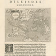
This early map of the East Indies and Indochina is one of the earliest obtainable maps of the region. It is from the 1576 second edition of Porcacchi’s L'Isole piu famose del Mondo, the Isolario or Book of Islands. Published in Venice, it depicts southeast Asia including Malaysia, Cambodia and Indonesia, along with the Philippines, Borneo, Java and Sumatra.
This map differs from others of the same era in that Porcacchi was among the pioneers of copperplate engraving, thus his maps depict finer details than earlier woodcut versions. Explanatory texts containing historical, geographic, ethnographic and mythological information for the regions depicted accompany his maps. This map contains explanatory text below the image and on the verso.
Tomaso Porcacchi was born in a poor family but became an esteemed member of Italian literati, thanks to the patronage of Duke Cosimo I de Medici, who funded his education and acquainted him with the best known Italian humanists of the day. Lodovico Domenichi, renowned for his editions and translations of classical authors, helped Porcacchi publish his first works, which included a biography of Vergil and a translation of the Aeneid. Thanks to the recommendations of Domenichi, Porcacchi became acquainted with prominent scholars, academicians, writers and publishers, providing a great boost to his career.
He left Florence in 1559 and settled in Venice where he stayed for the remainder of his life. While there he published a number of historical, archaeological and geographical works along with translations of texts from Greek to Latin. His anthology of southeast Asia and its islands is among the most notable of his geographical works. His work continued to be published well into the 18th century, long after his death.
Condition: This map is in A condition presenting a heavy impression on clean and sturdy paper without any holes or tears.
Inventory #12073
1200 W. 35th Street #425 Chicago, IL 60609 | P: (312) 496 - 3622