


1852 New Sectional Map of the State of Illinois...
Map Makers J.M. Peck, John Messinger, and A.J. Mathewson
Published By: James H. Colton
Date: 1852 (dated) New York
Dimensions: 41 x 28 inches (104 x 71 cm)
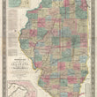
This is a rather scarce pocket map of Illinois that has recently been professionally flattened and linen-backed for preservation and presentation purposes.
This large format map presents the state of Illinois, surveyed in its entirety and colored in by country with cities, towns, villages, and post offices noted throughout. The map is also filled with numerous railroad lines, some of which are completed (solid lines) and many that are proposed and/or under construction (dashed lines).
The map was made at a pivotal point in history as it pertains to the mid-western states. Many of the Native American tribes from the area have been moved west of the Mississippi and the region was entering the age of the American railroad and westward expansion. While Missouri is known as the "gateway to the west," Illinois would act as an artery to which raw materials and goods would come to Chicago from the east before being dispersed via canal and railway to western settlements up and down the Mississippi River and beyond.
This map includes two inset maps. One of the "Vicinity of Galena, the Lead Region and part of Wisconsin and Iowa," and another of the "Vicinity of Alton & St. Louis." These insets would changed in later editions of this map to insets of Chicago and St. Louis.
Condition: This map is in A condition with no major fold separations. The map itself is very clean with bright colors and presents itself very nicely flattened and linen-backed.
Inventory #11914
1200 W. 35th Street #425 Chicago, IL 60609 | P: (312) 496 - 3622