


1855 Morse's Map of Indiana
By: Charles W Morse Published By: Rufus Blanchard
Date: 1855 (dated) Chicago
Dimensions: 31.25 x 23.5 inches (79.5 x 59.7 cm)
A very rare pocket map of Indiana from the mid-19th century of which worldcat.org notes only three known institutional examples at University of Chicago, University of Illinois at Urbana Champaign, and Indiana State Library.
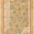
This rare, antique map of Indiana shows the state at a pivotal point in history, just decade after a half-century of indian removal treaties and acts and at the start of an American railroad revolution that would connect the country and turn the mid-western states into an industrial powerhouse.
Many of the states' earliest towns and fort are noted and several are interconnected by a web of new canals and roads. Proposed railroads are delineated throughout the map, including the Fort Wayne & Chicago R.R., and the Cincinnati Logansport & Chicago R.R. A newly completed line connecting Chicago to Detroit is shown with a dotted line.
Like the state of Illinois, Indiana progressively grew in population from the Ohio River Valley in the south to the north from the early 1800s to the 1860s. During that time, there were a series of battles, treaties, and congressional acts to remove the Native Americans from their ancestral homes to land in the designated Indian Territory west of the Mississippi. The Delaware, Piankashaw, Kickapoo, and Shawnee were removed in the 1820s and 1830s but the removal of the Potawatomi and Miami tribes were more drawn out. Many tribal leader successfully held onto lands granted to the by the Treaty of St. Mary's of 1818, only to eventually give them up by the mid-1840s and move west to the Kansas Territory.
As previously stated, this map is quite rare and only a few similar examples of other states such as Wisconsin and Illinois are held in a handful of institutional collections. It was originally printed as a wax lithograph pocket map and features a decorative floral border surrounding the map.
Condition: This map is in B condition, originally issued folding, now flattened and linen-backed for preservation purposes. The map shows signs of age and use through soiling, abrasions, and fold separations that have been professionally restored and filled where needed.
Inventory #11913
1200 W. 35th Street #425 Chicago, IL 60609 | P: (312) 496 - 3622